Eastern Ladakh is where the coach tours run out of road. This is the Changthang — a high cold desert bolted onto the Tibetan border, where the villages are counted in households and the lakes sit higher than most mountains you have climbed.
It is the only place on Earth where you can ride the two highest motorable roads in the world — Umling La and Mig La — in two days, from one village. In between: Pangong, the 1962 battlefield at Rezang La, Hanle’s observatory under the darkest sky in India, and Tso Moriri.
Khardung La still wears the sign that says highest motorable road in the world. It has not been true for years, and this route goes on to the two roads that took the title.
We ride it on Royal Enfields as a Leh-to-Leh loop: fly into Leh, acclimatise, cross Khardung La into Nubra, drop to Pangong, then work south across the plateau to Hanle and the record passes before closing the loop through Tso Moriri and the Indus back to Leh.

Eastern Ladakh is where the coach tours run out of road. This is the Changthang — a high cold desert bolted onto the Tibetan border, where the villages are counted in households and the lakes sit higher than most mountains you have climbed.
It is the only place on Earth where you can ride the two highest motorable roads in the world — Umling La and Mig La — in two days, from one village. In between: Pangong, the 1962 battlefield at Rezang La, Hanle’s observatory under the darkest sky in India, and Tso Moriri.
Khardung La still wears the sign that says highest motorable road in the world. It has not been true for years, and this route goes on to the two roads that took the title.
We ride it on Royal Enfields as a Leh-to-Leh loop: fly into Leh, acclimatise, cross Khardung La into Nubra, drop to Pangong, then work south across the plateau to Hanle and the record passes before closing the loop through Tso Moriri and the Indus back to Leh.
This is not a loop you knock off casually. Leh to Nubra over Khardung La, the Shyok to Pangong, then the border track south over Rezang La and Tsaga La to Hanle — base for the two record passes, Umling La and Mig La. Out through Namshang La to Tso Moriri, the Indus hot springs at Chumathang, and home to Leh.

Welcome to Delhi — vibrant, loud, and delicious; where aromas, colours, and crowds form the world’s most efficient assault on your senses. Exactly the warm-up your senses need before Ladakh. Airport pickup, hotel check-in. Evening: Welcome Dinner. You meet the crew, other riders, and your future adventure family. The jokes start early; the bragging rights start later.
A spectacular flight over the Himalayas drops you into Leh at 11,483 ft. Hotel check-in, gear check, and altitude acclimatization. Evening briefing, bike allocation, and a short walk to the market for momos and chai. Early night recommended.
Gentle ride around Leh — Shanti Stupa, Leh Palace, Indus–Zanskar Confluence — just enough to wake up the bikes and the riders. Final gear check, final instructions, no heroics.
The legendary climb to Khardung La, one of the world’s highest motorable passes. Views big enough to make your problems feel small. Photo stop, then descend into Nubra’s wide valley, monasteries and dunes. Desert, mountains and double-humped camels in one frame.
Remote, dramatic route following the Shyok river. Gravel, water crossings and scenery that looks fake. End the day at the legendary Pangong Tso, shining shades of blue during the day, and freezing by night.
You leave the selfie-stick end of Pangong behind and turn south down the border track, where the tourists stop and the army begins. You take in the Rezang La memorial (the pass itself, 5,005 m, sits up on the LAC), grind over Tsaga La at 15,207 ft, and the plateau opens into a great brown nothing that goes on for hours — until Hanle appears, and with it the darkest sky in India. Passes: Rezang La 5,005 m and Tsaga La 4,635 m.
The old record. Umling La at 19,024 feet was the highest motorable road on Earth from 2017 until its own neighbour beat it, and it is still higher than anywhere you have ever put a wheel. An out-and-back onto a ridgeline where the air holds barely half the oxygen of Delhi.
The new record. Mig La at 19,400 feet took the world’s-highest-motorable-road crown off Umling La in October 2025 — a raw, barely-finished border road toward Fukche, built by an all-woman BRO company. You will have ridden both in two days.
You come down off the record-books and turn the plateau into a lake district. A fast, empty tarred run to Loma, then the Indus, then a boulder-strewn climb over Namshang La (16,273 ft) and past a string of high lakes to Tso Moriri — 4,522 m of Ramsar-listed blue, with the kiang and the bar-headed geese and the 400-year-old gompa at Korzok. Pass: Namshang La 4,960 m.
A short, deliberate day. You leave the lake, cross back over Namshang La, drop to the Indus, and stop early at Chumathang — where the river runs past ground that is quietly boiling. Hot springs at 60C steaming out of a cold desert bank, a soak, and an easy night. Pass: Namshang La 4,960 m (re-crossed).
The way home nobody talks about. Instead of the standard high-pass highway, you follow the Indus the whole way — a river-gorge road through colour-shot mountains that gets called one of the most scenic stretches in Ladakh, and that almost no tour bus uses. No big pass today. Just the river, and the road slowly civilising back into Leh.
A relaxed day, and an earned one. No passes, no permits, no fuel anxiety — just the great monasteries of the central Indus valley, ridden as an easy loop out of Leh and back: Hemis, Thiksey and Shey, a thousand years of the culture you have been riding through.
You say goodbye to the Roof of the World, trading prayer flags and thin air for a spectacular flight back to Delhi. By nightfall, the mountains are behind you and the music is loud — time for a farewell party. Boots off, stories on repeat.
Breakfast, airport drop, emotional goodbyes, heartfelt promises to ride again, and a strong chance you’ll book the next expedition within a week.
Met on arrival at Terminal 3 and transferred to the group hotel. Delhi sits at roughly 216 m — the lowest point of the entire expedition, and deliberately so.
First meeting of the full squad, the ride leaders and the mechanic. Route brief, bike allocation preview, and the medical and altitude briefing.
Altitudes: Delhi 216 m → Leh 3,500 m in roughly 80 minutes. This is the single largest altitude gain of the trip and the reason Day 03 exists.
The approach into Leh runs along the main Himalayan range — Nun Kun and the Zanskar wall on a clear morning. Sit on the left side heading north.
The District Leh administration requires all arriving tourists to complete at least 48 hours of acclimatization before travelling to higher areas. Khardung La and Pangong are closed to you until that window is served. Today is complete rest — no walking tours, no bike riding, 3–4 litres of water.
Machines assigned, luggage system explained, and a walk-through of what rides on the support vehicle versus what rides with you.
Distances measured from Leh Main Bazaar. 77 km total loop. Net sleeping-altitude gain for the day: zero — you sleep at 11,483 ft tonight, same as last night. That is the entire point of this day.
The old-town market street below the palace. Fill every tank here — there are five verified pumps on today's loop but only one after Pathar Sahib.
A Japanese-built Peace Pagoda on the Chanspa ridge, begun 1983 and completed 1991 by the monk Gyomyo Nakamura; the Dalai Lama laid its foundation relics in 1985. Ride the tarred road to the gate — the 555 steps from the base are an unnecessary exertion load on day three.
Nine storeys of mud-brick and timber raised around 1600 by King Sengge Namgyal. The Potala in Lhasa was built forty-five years later in the same style — Leh Palace is the ancestor, not the copy. Interior is unlit with open drops; carry a torch.
The highest point of your day, on the crag above the palace, holding a three-storey gold Maitreya. Two warnings: it is shut through the middle of the day, and the last stretch is a steep foot climb on rough steps at the day's altitude maximum. Optional for anyone feeling the altitude.
Gelugpa gompa on a cone of rock directly above the Leh airport runway, founded in the 11th century and taken over by the Yellow Hats in the 15th. Its giant Vajrabhairava is unveiled only at the Gustor festival. Afternoon closure is real — take it on the way out, not back.
Where the grey-green Zanskar comes out of its gorge and hits the browner Indus, the two colours refusing to mix for several hundred metres. Best between 10:00 and 14:00 with the sun overhead. In deep winter this frozen river is the start of the Chadar trek.
Back on NH1 over the 3,537 m rise at Pathar Sahib and down into town. Final gear check, final instructions, early night.
Distances measured from Leh. Realistic journey time 5–6 hours for the riding alone — single-lane two-way traffic holds speeds to around 30 km/h even on good tarmac. An early start is not optional on a long, slow pass day.
Multiple pumps and the last reliable ATMs on the entire route. Carry four to five paper photocopies of your permit per rider — checkposts keep one each and digital copies on a phone are not accepted.
The southern barrier post, where permits are registered and a photocopy surrendered. This is the day's queue bottleneck — build slack here rather than trying to make it up on the pass.
The summit signboard reads 5,602 m / 18,380 ft. Independent GPS, SRTM, ASTER and Russian topographic surveys all put it at 5,359 m / 17,582 ft, and a 2011 Catalan expedition confirmed it. We publish the surveyed figure and tell you the sign is wrong — you will photograph it and you deserve to know. Twenty minutes maximum: no running about, no smoking, no heavy meal. Free black tea at the army canteen.
Second barrier, second photocopy. The descent to here is the day's other bad stretch — badly damaged surface, potholes and puddles of icy water on a steep drop.
T-junction on the Shyok where the road splits: west to Diskit, Hunder and Turtuk, north to Sumur and Panamik. There is an IndianOil pump here but it queues badly and runs dry — treat Leh as your last certain fuel, not this.
Administrative seat of Nubra, with the valley's oldest and largest gompa founded in the 14th century sitting 200 m above the village. Below it stands the 32 m Maitreya Buddha, consecrated by the Dalai Lama in July 2010, facing north toward the border. The most reliable pump in the valley, working even in winter.
Seven kilometres of white cold-desert dunes between Diskit and Hunder, grazed by double-humped Bactrian camels descended from Silk Road caravan stock stranded here when the Central Asian trade routes closed. Best light before 08:00 and after 16:30.
Distances measured from Hunder. The hard part is a single, well-defined 25 km section immediately east of Agham — not the whole day. Expect around ten hours door to door including stops.
A long day with a rough, unpaved riverbed section mid-route. Start early to keep margin on a single-lane road of blind curves and water crossings; Ladakhi operators put the departure cutoff at 07:30.
The only authorised pump in Nubra. The next one is Tangtse, 124 km further on, with the entire unpaved section in between. Fill everything, including cans. Availability here is reported as intermittent — if it is dry, the day does not run.
Beyond Agham there is no turning option for forty-five kilometres. Stop here and talk to every vehicle coming the other way about water levels and washouts. If the answer is bad, the fallback is Wari La — a 220 km, eight-to-ten-hour day over two 5,000 m passes.
For several kilometres past Agham the dried bed of the Shyok literally is the road. The hazard is not fixed fords — it is the river itself migrating onto the carriageway, so the crossings move year to year and after every storm. Exceptionally narrow, frequent blind curves, and the river running parallel at almost the same level.
A green oasis in the gorge, historically on the winter caravan route from Leh to Yarkand and on to Kashgar over the Karakoram Pass until 1937. Dhabas now run here — Maggi, soup and chai — and the tarmac resumes.
T-junction onto the main Leh–Chang La–Pangong highway, and the northern terminus of the 255 km Darbuk–Shyok–Daulat Beg Oldi strategic road opened in 2019. From here it is good tarmac all the way.
An IndianOil pump has operated here since 2023 and works through winter. Tangtse is also the most important rock-art site in Ladakh, with around 300 petroglyphs and 70 inscriptions in Tocharian, Sogdian, Sharada and Arabic script from its days on the Turkestan–Tibet trade route.
The reveal. Build it into the schedule rather than letting the group stop raggedly on a live road.
The lake runs 134 km with roughly 45 km on the Indian side; the Line of Actual Control crosses at Finger 8. The western basin is saline and the eastern fresh, and the whole thing freezes solid in winter despite the salt. Lakeside camping was banned in 2018 and enforced with bulldozers — every licensed camp now sits back inside the village boundary. Electricity for a few hours in the evening only.
New-route distances are approximate (~200–240 km via Man–Merak–Chushul) and will be OSRM-measured in build. This is a long, mostly rough day on the plateau. Fuel: there is none. Your last certain tank was Tangtse on Day 05; carry cans / support-vehicle fuel — Nyoma's pump is unreliable and Hanle has none. Inner Line Permit checked at Loma.
No fuel at Pangong and none again until well past Hanle. This is the day the fuel plan set in Leh either works or ends the ride. Full tanks and cans before you roll.
The tarred shore spur runs out at Merak. From here the road south to Chushul is a broken dirt trail — the 3–4 hour version of what a map draws as a thin confident line.
A wide, wind-flattened plain settlement in the 1962 war sector, heavy military presence and close to the Line of Actual Control. You are a guest on an operational frontier here, not a sightseer — ride through the sensitive stretches, do not photograph installations.
Rezang La proper is a 5,005 m (16,420 ft) pass on the watershed ridge right on the Line of Actual Control — reached only by a military patrol road, not this one; what you ride to is the War Memorial on the Chushul plain below it. It marks the last stand of Charlie Company, 13 Kumaon — 114 men held the ridge against a far larger Chinese force on 18 November 1962 and were found later at their posts, out of ammunition. Major Shaitan Singh was awarded a posthumous Param Vir Chakra. The memorial, first built in 1963, has been rebuilt with a two-storey museum, a documentary theatre and a helipad. You take your helmet off here.
The pass you actually cross on this route — a high, sandy, boulder-strewn climb over the shoulder of the plateau, with no fuel, no food and no mobile signal between Chushul and Loma. No photogenic signboard, just a long grind at altitude.
The bridge and checkpost where you rejoin the Indus and your Inner Line Permit is registered. ⚠ Camera/photography rules here and onward to Hanle have varied year to year (older camera ban vs the relaxed Dark-Sky era) — confirm the current 2026 rule before we publish this line.
Sub-divisional town on the Indus with a monastery on the hillside. There is a fuel pump here, reported on-and-off / under construction — plan as if it is not there.
The end of the road and the point of the whole day. Hanle holds the Indian Astronomical Observatory — a 2 m optical telescope and the MACE, the world's highest imaging Cherenkov telescope (2024) — a 17th-century gompa on the hill, and India's first Dark Sky Reserve: Bortle-1 skies, roughly 270 cloud-free nights a year. No fuel in the village. Stay up for the sky; you will not see one darker.
Out-and-back day trip from Hanle; you sleep in Hanle again tonight. Distances approximate (~72–108 km one-way depending on source) — to be OSRM-measured. No fuel, no food, no medical facility past Hanle: carry water, snacks and a rescue plan. Start pre-dawn to be down before the afternoon wind. Photi La's exact altitude varies by source (16,900–18,124 ft) and will be pinned in build.
Everything today runs on fuel carried in. Leave in the dark; the pass is best done early and the day is long for the distance because of the surface and the altitude.
The climb out of Hanle over Photi La — loose mud, stones and gravel. This is the pass that does the vertical work; Umling La beyond it is higher but the road there is better.
A Border Roads camp on the far side of Photi La, with river crossings below it where bridges are still going in. The last sign of anyone until the pass.
The village where the Chisumle–Umling La–Demchok road begins — the 52 km BRO alignment, Project Himank, that carried Umling La to its record in 2017.
The top. On the ridge dividing Koyul Lungpa and the Indus, 25 km east of Chisumle, and the world's highest motorable road from 2017 until Mig La took the title in 2025. At this height the smallest exertion costs you — photographs, then down. No lingering, no heroics, no heavy meal.
Back down the way you came to Hanle and its sky. Tomorrow, the other record.
Out-and-back day trip from Hanle. Mig La sits on the 64 km Likaru–Mig La–Fukche (LMLF) road, BRO / Project Himank, opened as the world's highest motorable road in October 2025. Fukche is ~3 km from the LAC — this is a live, sensitive military sector: access and photography can be restricted or suspended at short notice; ⚠ confirm current tourist-access status before we publish. No fuel; carry cans.
Shorter than the Umling La day but no less serious for altitude. Fuel carried in; early start.
The hamlet where the LMLF road begins its climb — 12 km out of Hanle, the last named place before the pass.
The highest motorable road on the planet since October 2025, roughly 33 km of new BRO road beyond Likaru, running on toward the Fukche advanced landing ground about 3 km from the Line of Actual Control. Raw surface, thinner air than Umling La, and a summit almost no one has stood on. This is a border road first and a tourist road second — ride it as such.
Back to Hanle. Two of the highest roads on Earth, done from one village, in two days — there is nowhere else you can say that.
Approximate distances (~160 km, ~8 hrs): Hanle→Loma ~50 km (good tar), Loma→Nyoma ~30 km, Nyoma→Mahe ~20 km, Mahe→Korzok via Sumdo & Kyagar Tso ~60 km — to be OSRM-measured. Fuel: Nyoma pump unreliable; there is none at Korzok, so this is still run on the reserves you have been carrying. Wildlife checkposts around Tso Moriri; it is a protected wetland.
The 50 km back out to Loma is the best surface you have had in days — narrow, empty, tarred. Enjoy it; it does not last.
Back onto the Indus and the permit post. From here the road quality starts its slow slide from good to boulder.
The Indus town again, monastery on the hill. Same unreliable pump — do not build the day around it.
Cross the Indus at Mahe bridge and turn south off the through-road onto the Sumdo–Korzok road toward the lakes.
The pass that lifts you off the Indus valley onto the Tso Moriri plateau — a recently paved black-top crossing on the 45 km Sumdo–Korzok road, remote, no villages, no fuel. This is the day's high point.
A small, startlingly emerald lake on the climb in — the warm-up act before Tso Moriri, and where several riders quietly decide it is the prettier of the two. The tarred road turns to boulder around here.
Tso Moriri runs 26 km north to south at 4,522 m — a Ramsar-listed wetland and conservation reserve, the only Indian breeding ground of the bar-headed goose, home to kiang and the endangered black-necked crane. Korzok village on the northwest shore holds a roughly 400-year-old gompa and is the only year-round settlement on the lake. Camps and guesthouses sit back from the water; no fuel here.
Approximate ~79 km (Korzok→Sumdo→Mahe bridge→Chumathang) — to be OSRM-measured. This is intentionally a half-day: it splits the long Korzok→Leh haul and puts a hot-spring soak and a low(er)-altitude night in the middle. The Chumathang→Mahe stretch is under construction and slow in patches.
Back down off the lake toward the Indus the way you came in.
The Sumdo–Korzok pass again, this time coming off the Tso Moriri plateau and dropping back toward the Indus.
At Mahe you rejoin the river road and turn downstream toward Chumathang and, tomorrow, Leh.
A village strung along the Indus where geothermal water breaks out of the bank at close to 60°C, steaming against the cold. There are guesthouses at the springs themselves — a hot soak at over 13,000 ft, and the lowest, easiest night you have had since Leh. Take it; Day 11 is long.
Approximate ~141 km (Chumathang→Upshi ~92 km, Upshi→Karu ~14 km, Karu→Leh ~35 km) — to be OSRM-measured. A low river-valley road, no high pass; scenic and good from Upshi in, rougher/construction Chumathang→Upshi in patches. This is the deliberate alternative to the More Plains / Tanglang La highway.
Downstream along the Indus, the river on one side and bare, mineral-streaked mountains on the other.
Where the river road meets the Manali–Leh highway. The surface turns to good tar from here and the dhabas reappear — the practical lunch halt.
Junction town with fuel, and the gateway to the monastery cluster you ride tomorrow — Hemis lies up the side valley from here. Good tarmac all the way in now.
Home again after the loop, on the same hotel you left. Workshops, ATMs, a proper meal, and a night that is not on a plateau.
Easy tarred loop from Leh (~90 km, approximate) — the trip's recovery day before flying out. Thiksey and Shey reuse Rajeev's measured Ladakh figures; distances here are approximate and to be confirmed. Check monastery midday closures before setting the order.
A civilised departure time for once. Everything today is tar, low, and optional.
The largest and wealthiest gompa in Ladakh, tucked into a side gorge off the Indus about 45 km from Leh and re-established under King Sengge Namgyal in the 17th century as the seat of the Drukpa Kagyu order. Its famous Hemis festival honours Guru Padmasambhava, and its giant thangka is unfurled only once every twelve years. The museum below holds the order's treasures.
Twelve storeys stacked up a hill, the largest gompa in central Ladakh and universally called the mini-Potala. Its 15 m Maitreya spans two floors and was installed in 1970 to mark the Dalai Lama's visit — the largest such statue in Ladakh. Two cafés and toilets at the base.
Summer capital of the Namgyal kings, with a 39 ft Shakyamuni gilded in gold, built in 1655 by King Deldan Namgyal — the largest gold-gilded statue in Ladakh. Ruined palace walls, a chorten field and the Indus valley laid out below.
Back into town for the last night, the group dinner and the count of everything you crossed.
Leh airport clears early and weather cancellations happen — the transfer leaves the hotel well before dawn.
Certificates, the ride video, and the stories that have grown considerably since Umling La.
Timed to your flight. Bear in mind Delhi traffic and international check-in windows.

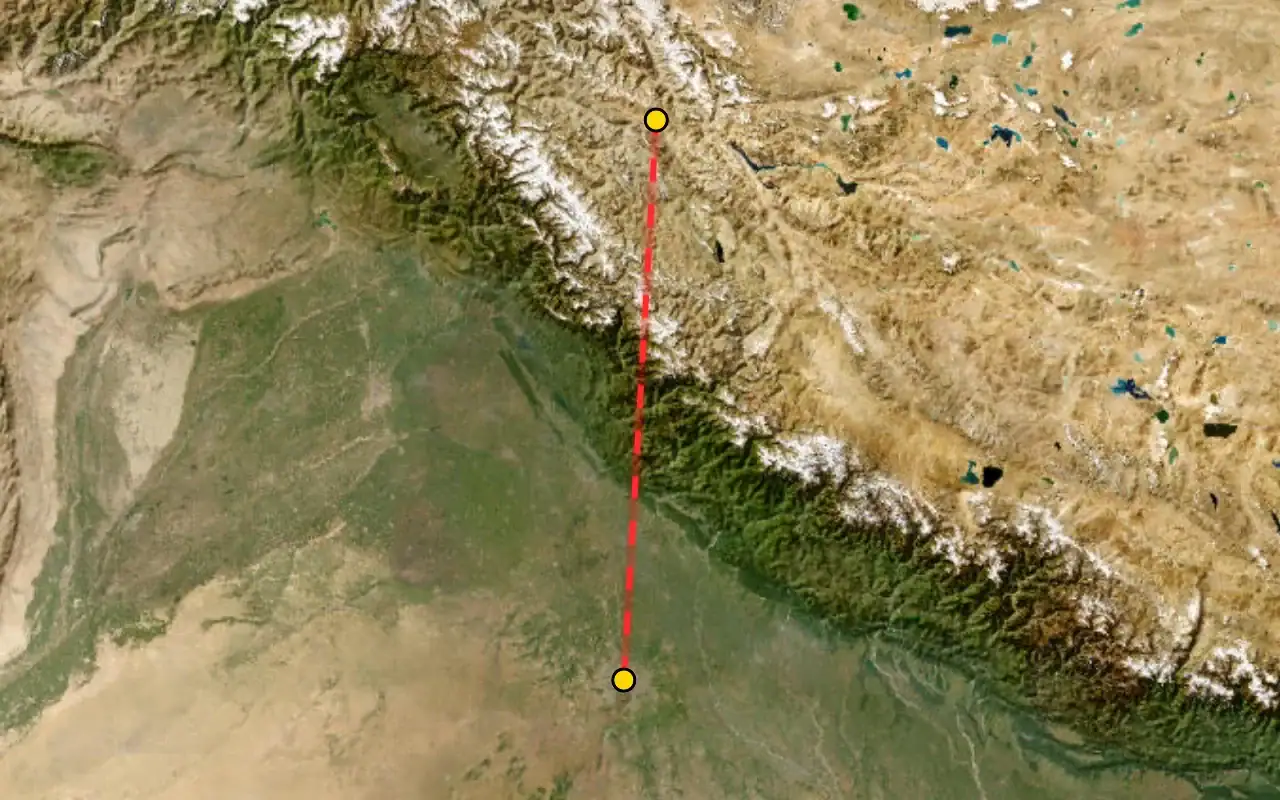


Met on arrival at Terminal 3 and transferred to the group hotel. Delhi sits at roughly 216 m — the lowest point of the entire expedition, and deliberately so.
First meeting of the full squad, the ride leaders and the mechanic. Route brief, bike allocation preview, and the medical and altitude briefing.
Altitudes: Delhi 216 m → Leh 3,500 m in roughly 80 minutes. This is the single largest altitude gain of the trip and the reason Day 03 exists.
The approach into Leh runs along the main Himalayan range — Nun Kun and the Zanskar wall on a clear morning. Sit on the left side heading north.
The District Leh administration requires all arriving tourists to complete at least 48 hours of acclimatization before travelling to higher areas. Khardung La and Pangong are closed to you until that window is served. Today is complete rest — no walking tours, no bike riding, 3–4 litres of water.
Machines assigned, luggage system explained, and a walk-through of what rides on the support vehicle versus what rides with you.
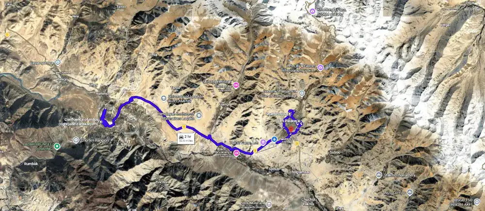
Distances measured from Leh Main Bazaar. 77 km total loop. Net sleeping-altitude gain for the day: zero — you sleep at 11,483 ft tonight, same as last night. That is the entire point of this day.
The old-town market street below the palace. Fill every tank here — there are five verified pumps on today's loop but only one after Pathar Sahib.
A Japanese-built Peace Pagoda on the Chanspa ridge, begun 1983 and completed 1991 by the monk Gyomyo Nakamura; the Dalai Lama laid its foundation relics in 1985. Ride the tarred road to the gate — the 555 steps from the base are an unnecessary exertion load on day three.
Nine storeys of mud-brick and timber raised around 1600 by King Sengge Namgyal. The Potala in Lhasa was built forty-five years later in the same style — Leh Palace is the ancestor, not the copy. Interior is unlit with open drops; carry a torch.
The highest point of your day, on the crag above the palace, holding a three-storey gold Maitreya. Two warnings: it is shut through the middle of the day, and the last stretch is a steep foot climb on rough steps at the day's altitude maximum. Optional for anyone feeling the altitude.
Gelugpa gompa on a cone of rock directly above the Leh airport runway, founded in the 11th century and taken over by the Yellow Hats in the 15th. Its giant Vajrabhairava is unveiled only at the Gustor festival. Afternoon closure is real — take it on the way out, not back.
Where the grey-green Zanskar comes out of its gorge and hits the browner Indus, the two colours refusing to mix for several hundred metres. Best between 10:00 and 14:00 with the sun overhead. In deep winter this frozen river is the start of the Chadar trek.
Back on NH1 over the 3,537 m rise at Pathar Sahib and down into town. Final gear check, final instructions, early night.
Distances measured from Leh. Realistic journey time 5–6 hours for the riding alone — single-lane two-way traffic holds speeds to around 30 km/h even on good tarmac. An early start is not optional on a long, slow pass day.
Multiple pumps and the last reliable ATMs on the entire route. Carry four to five paper photocopies of your permit per rider — checkposts keep one each and digital copies on a phone are not accepted.
The southern barrier post, where permits are registered and a photocopy surrendered. This is the day's queue bottleneck — build slack here rather than trying to make it up on the pass.
The summit signboard reads 5,602 m / 18,380 ft. Independent GPS, SRTM, ASTER and Russian topographic surveys all put it at 5,359 m / 17,582 ft, and a 2011 Catalan expedition confirmed it. We publish the surveyed figure and tell you the sign is wrong — you will photograph it and you deserve to know. Twenty minutes maximum: no running about, no smoking, no heavy meal. Free black tea at the army canteen.
Second barrier, second photocopy. The descent to here is the day's other bad stretch — badly damaged surface, potholes and puddles of icy water on a steep drop.
T-junction on the Shyok where the road splits: west to Diskit, Hunder and Turtuk, north to Sumur and Panamik. There is an IndianOil pump here but it queues badly and runs dry — treat Leh as your last certain fuel, not this.
Administrative seat of Nubra, with the valley's oldest and largest gompa founded in the 14th century sitting 200 m above the village. Below it stands the 32 m Maitreya Buddha, consecrated by the Dalai Lama in July 2010, facing north toward the border. The most reliable pump in the valley, working even in winter.
Seven kilometres of white cold-desert dunes between Diskit and Hunder, grazed by double-humped Bactrian camels descended from Silk Road caravan stock stranded here when the Central Asian trade routes closed. Best light before 08:00 and after 16:30.
Distances measured from Hunder. The hard part is a single, well-defined 25 km section immediately east of Agham — not the whole day. Expect around ten hours door to door including stops.
A long day with a rough, unpaved riverbed section mid-route. Start early to keep margin on a single-lane road of blind curves and water crossings; Ladakhi operators put the departure cutoff at 07:30.
The only authorised pump in Nubra. The next one is Tangtse, 124 km further on, with the entire unpaved section in between. Fill everything, including cans. Availability here is reported as intermittent — if it is dry, the day does not run.
Beyond Agham there is no turning option for forty-five kilometres. Stop here and talk to every vehicle coming the other way about water levels and washouts. If the answer is bad, the fallback is Wari La — a 220 km, eight-to-ten-hour day over two 5,000 m passes.
For several kilometres past Agham the dried bed of the Shyok literally is the road. The hazard is not fixed fords — it is the river itself migrating onto the carriageway, so the crossings move year to year and after every storm. Exceptionally narrow, frequent blind curves, and the river running parallel at almost the same level.
A green oasis in the gorge, historically on the winter caravan route from Leh to Yarkand and on to Kashgar over the Karakoram Pass until 1937. Dhabas now run here — Maggi, soup and chai — and the tarmac resumes.
T-junction onto the main Leh–Chang La–Pangong highway, and the northern terminus of the 255 km Darbuk–Shyok–Daulat Beg Oldi strategic road opened in 2019. From here it is good tarmac all the way.
An IndianOil pump has operated here since 2023 and works through winter. Tangtse is also the most important rock-art site in Ladakh, with around 300 petroglyphs and 70 inscriptions in Tocharian, Sogdian, Sharada and Arabic script from its days on the Turkestan–Tibet trade route.
The reveal. Build it into the schedule rather than letting the group stop raggedly on a live road.
The lake runs 134 km with roughly 45 km on the Indian side; the Line of Actual Control crosses at Finger 8. The western basin is saline and the eastern fresh, and the whole thing freezes solid in winter despite the salt. Lakeside camping was banned in 2018 and enforced with bulldozers — every licensed camp now sits back inside the village boundary. Electricity for a few hours in the evening only.
New-route distances are approximate (~200–240 km via Man–Merak–Chushul) and will be OSRM-measured in build. This is a long, mostly rough day on the plateau. Fuel: there is none. Your last certain tank was Tangtse on Day 05; carry cans / support-vehicle fuel — Nyoma's pump is unreliable and Hanle has none. Inner Line Permit checked at Loma.
No fuel at Pangong and none again until well past Hanle. This is the day the fuel plan set in Leh either works or ends the ride. Full tanks and cans before you roll.
The tarred shore spur runs out at Merak. From here the road south to Chushul is a broken dirt trail — the 3–4 hour version of what a map draws as a thin confident line.
A wide, wind-flattened plain settlement in the 1962 war sector, heavy military presence and close to the Line of Actual Control. You are a guest on an operational frontier here, not a sightseer — ride through the sensitive stretches, do not photograph installations.
Rezang La proper is a 5,005 m (16,420 ft) pass on the watershed ridge right on the Line of Actual Control — reached only by a military patrol road, not this one; what you ride to is the War Memorial on the Chushul plain below it. It marks the last stand of Charlie Company, 13 Kumaon — 114 men held the ridge against a far larger Chinese force on 18 November 1962 and were found later at their posts, out of ammunition. Major Shaitan Singh was awarded a posthumous Param Vir Chakra. The memorial, first built in 1963, has been rebuilt with a two-storey museum, a documentary theatre and a helipad. You take your helmet off here.
The pass you actually cross on this route — a high, sandy, boulder-strewn climb over the shoulder of the plateau, with no fuel, no food and no mobile signal between Chushul and Loma. No photogenic signboard, just a long grind at altitude.
The bridge and checkpost where you rejoin the Indus and your Inner Line Permit is registered. ⚠ Camera/photography rules here and onward to Hanle have varied year to year (older camera ban vs the relaxed Dark-Sky era) — confirm the current 2026 rule before we publish this line.
Sub-divisional town on the Indus with a monastery on the hillside. There is a fuel pump here, reported on-and-off / under construction — plan as if it is not there.
The end of the road and the point of the whole day. Hanle holds the Indian Astronomical Observatory — a 2 m optical telescope and the MACE, the world's highest imaging Cherenkov telescope (2024) — a 17th-century gompa on the hill, and India's first Dark Sky Reserve: Bortle-1 skies, roughly 270 cloud-free nights a year. No fuel in the village. Stay up for the sky; you will not see one darker.
Out-and-back day trip from Hanle; you sleep in Hanle again tonight. Distances approximate (~72–108 km one-way depending on source) — to be OSRM-measured. No fuel, no food, no medical facility past Hanle: carry water, snacks and a rescue plan. Start pre-dawn to be down before the afternoon wind. Photi La's exact altitude varies by source (16,900–18,124 ft) and will be pinned in build.
Everything today runs on fuel carried in. Leave in the dark; the pass is best done early and the day is long for the distance because of the surface and the altitude.
The climb out of Hanle over Photi La — loose mud, stones and gravel. This is the pass that does the vertical work; Umling La beyond it is higher but the road there is better.
A Border Roads camp on the far side of Photi La, with river crossings below it where bridges are still going in. The last sign of anyone until the pass.
The village where the Chisumle–Umling La–Demchok road begins — the 52 km BRO alignment, Project Himank, that carried Umling La to its record in 2017.
The top. On the ridge dividing Koyul Lungpa and the Indus, 25 km east of Chisumle, and the world's highest motorable road from 2017 until Mig La took the title in 2025. At this height the smallest exertion costs you — photographs, then down. No lingering, no heroics, no heavy meal.
Back down the way you came to Hanle and its sky. Tomorrow, the other record.
Out-and-back day trip from Hanle. Mig La sits on the 64 km Likaru–Mig La–Fukche (LMLF) road, BRO / Project Himank, opened as the world's highest motorable road in October 2025. Fukche is ~3 km from the LAC — this is a live, sensitive military sector: access and photography can be restricted or suspended at short notice; ⚠ confirm current tourist-access status before we publish. No fuel; carry cans.
Shorter than the Umling La day but no less serious for altitude. Fuel carried in; early start.
The hamlet where the LMLF road begins its climb — 12 km out of Hanle, the last named place before the pass.
The highest motorable road on the planet since October 2025, roughly 33 km of new BRO road beyond Likaru, running on toward the Fukche advanced landing ground about 3 km from the Line of Actual Control. Raw surface, thinner air than Umling La, and a summit almost no one has stood on. This is a border road first and a tourist road second — ride it as such.
Back to Hanle. Two of the highest roads on Earth, done from one village, in two days — there is nowhere else you can say that.
Approximate distances (~160 km, ~8 hrs): Hanle→Loma ~50 km (good tar), Loma→Nyoma ~30 km, Nyoma→Mahe ~20 km, Mahe→Korzok via Sumdo & Kyagar Tso ~60 km — to be OSRM-measured. Fuel: Nyoma pump unreliable; there is none at Korzok, so this is still run on the reserves you have been carrying. Wildlife checkposts around Tso Moriri; it is a protected wetland.
The 50 km back out to Loma is the best surface you have had in days — narrow, empty, tarred. Enjoy it; it does not last.
Back onto the Indus and the permit post. From here the road quality starts its slow slide from good to boulder.
The Indus town again, monastery on the hill. Same unreliable pump — do not build the day around it.
Cross the Indus at Mahe bridge and turn south off the through-road onto the Sumdo–Korzok road toward the lakes.
The pass that lifts you off the Indus valley onto the Tso Moriri plateau — a recently paved black-top crossing on the 45 km Sumdo–Korzok road, remote, no villages, no fuel. This is the day's high point.
A small, startlingly emerald lake on the climb in — the warm-up act before Tso Moriri, and where several riders quietly decide it is the prettier of the two. The tarred road turns to boulder around here.
Tso Moriri runs 26 km north to south at 4,522 m — a Ramsar-listed wetland and conservation reserve, the only Indian breeding ground of the bar-headed goose, home to kiang and the endangered black-necked crane. Korzok village on the northwest shore holds a roughly 400-year-old gompa and is the only year-round settlement on the lake. Camps and guesthouses sit back from the water; no fuel here.
Approximate ~79 km (Korzok→Sumdo→Mahe bridge→Chumathang) — to be OSRM-measured. This is intentionally a half-day: it splits the long Korzok→Leh haul and puts a hot-spring soak and a low(er)-altitude night in the middle. The Chumathang→Mahe stretch is under construction and slow in patches.
Back down off the lake toward the Indus the way you came in.
The Sumdo–Korzok pass again, this time coming off the Tso Moriri plateau and dropping back toward the Indus.
At Mahe you rejoin the river road and turn downstream toward Chumathang and, tomorrow, Leh.
A village strung along the Indus where geothermal water breaks out of the bank at close to 60°C, steaming against the cold. There are guesthouses at the springs themselves — a hot soak at over 13,000 ft, and the lowest, easiest night you have had since Leh. Take it; Day 11 is long.
Approximate ~141 km (Chumathang→Upshi ~92 km, Upshi→Karu ~14 km, Karu→Leh ~35 km) — to be OSRM-measured. A low river-valley road, no high pass; scenic and good from Upshi in, rougher/construction Chumathang→Upshi in patches. This is the deliberate alternative to the More Plains / Tanglang La highway.
Downstream along the Indus, the river on one side and bare, mineral-streaked mountains on the other.
Where the river road meets the Manali–Leh highway. The surface turns to good tar from here and the dhabas reappear — the practical lunch halt.
Junction town with fuel, and the gateway to the monastery cluster you ride tomorrow — Hemis lies up the side valley from here. Good tarmac all the way in now.
Home again after the loop, on the same hotel you left. Workshops, ATMs, a proper meal, and a night that is not on a plateau.
Easy tarred loop from Leh (~90 km, approximate) — the trip's recovery day before flying out. Thiksey and Shey reuse Rajeev's measured Ladakh figures; distances here are approximate and to be confirmed. Check monastery midday closures before setting the order.
A civilised departure time for once. Everything today is tar, low, and optional.
The largest and wealthiest gompa in Ladakh, tucked into a side gorge off the Indus about 45 km from Leh and re-established under King Sengge Namgyal in the 17th century as the seat of the Drukpa Kagyu order. Its famous Hemis festival honours Guru Padmasambhava, and its giant thangka is unfurled only once every twelve years. The museum below holds the order's treasures.
Twelve storeys stacked up a hill, the largest gompa in central Ladakh and universally called the mini-Potala. Its 15 m Maitreya spans two floors and was installed in 1970 to mark the Dalai Lama's visit — the largest such statue in Ladakh. Two cafés and toilets at the base.
Summer capital of the Namgyal kings, with a 39 ft Shakyamuni gilded in gold, built in 1655 by King Deldan Namgyal — the largest gold-gilded statue in Ladakh. Ruined palace walls, a chorten field and the Indus valley laid out below.
Back into town for the last night, the group dinner and the count of everything you crossed.
Leh airport clears early and weather cancellations happen — the transfer leaves the hotel well before dawn.
Certificates, the ride video, and the stories that have grown considerably since Umling La.
Timed to your flight. Bear in mind Delhi traffic and international check-in windows.