Zanskar is not a sightseeing tour; it is a ride into one of the most isolated inhabited valleys in the Himalaya. For most of the year it is sealed off entirely — snowed in behind Pensi La and Shinku La, its people cut off from the outside world. You reach it only in the narrow summer window when the passes open, on roads that were through-connected as recently as 2024. This is high, thin, committing country: you sleep above 11,483 ft for nights on end and cross the ground on a motorcycle, not through a car window.
The name Zanskar is usually traced to zangs-dkar — “white copper” — for the metal once worked in these mountains and the pale, mineral-streaked rock that defines the valley. It lies in a deep trench between the Great Himalayan and Zanskar ranges, drained by the Stod, Lungnak and Zanskar rivers. Barley terraces, whitewashed gompas clinging to cliffs, and glaciers that run right to the roadside — this is the geology of the untouched, read straight off the landscape.
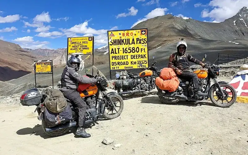
We ride it on Royal Enfields as a full loop: fly into Leh, cross into Zanskar over the Suru valley and Pensi La to Padum, exit south over the 16,703 ft Shinku La, and return to Leh over four high passes on the Manali–Leh highway. Fourteen days, deliberately paced with acclimatization and a contingency buffer built in — because this is not a route you rush.
The Zanskar Valley is the reason for the whole route: everything before Pensi La is the approach, and everything after Shinku La is the way home.
Zanskar is not a sightseeing tour; it is a ride into one of the most isolated inhabited valleys in the Himalaya. For most of the year it is sealed off entirely — snowed in behind Pensi La and Shinku La, its people cut off from the outside world. You reach it only in the narrow summer window when the passes open, on roads that were through-connected as recently as 2024. This is high, thin, committing country: you sleep above 11,483 ft for nights on end and cross the ground on a motorcycle, not through a car window.
The name Zanskar is usually traced to zangs-dkar — "white copper" — for the metal once worked in these mountains and the pale, mineral-streaked rock that defines the valley. It lies in a deep trench between the Great Himalayan and Zanskar ranges, drained by the Stod, Lungnak and Zanskar rivers. Barley terraces, whitewashed gompas clinging to cliffs, and glaciers that run right to the roadside — this is the geology of the untouched, read straight off the landscape.
We ride it on Royal Enfields as a full loop: fly into Leh, cross into Zanskar over the Suru valley and Pensi La to Padum, exit south over the 16,703 ft Shinku La, and return to Leh over four high passes on the Manali–Leh highway. Fourteen days, deliberately paced with acclimatization and a contingency buffer built in — because this is not a route you rush.
The Zanskar Valley is the reason for the whole route: everything before Pensi La is the approach, and everything after Shinku La is the way home.
This is not a loop you casually knock off over a long weekend. It is a full circle through the least-travelled corner of Ladakh: in over the Suru valley and Pensi La to Padum, deep south along the freshly black-topped Tsarap road to the Phugtal gateway at Purne, out over the 16,703 ft Shinku La — Zanskar’s dramatic new southern exit — and back to Leh over Baralacha La, Nakee La, Lachulung La and Tanglang La. Every distance below is measured on real road data, every altitude cross-checked against survey and satellite figures.
Welcome to Delhi — vibrant, loud, and delicious; where aromas, colours, and crowds form the world’s most efficient assault on your senses. Exactly the warm-up your senses need before Ladakh. Airport pickup, hotel check-in. Evening: Welcome Dinner. You meet the crew, other riders, and your future adventure family. The jokes start early; the bragging rights start later.
A spectacular flight over the Himalayas drops you into Leh at 11,483 ft. Hotel check-in, gear check, and altitude acclimatization. Evening briefing, bike allocation, and a short walk to the market for momos and chai. Early night recommended.
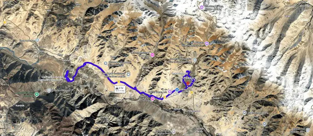
Gentle ride around Leh — Shanti Stupa, Leh Palace, Indus–Zanskar Confluence — just enough to wake up the bikes and the riders. Final gear check, final instructions, no heroics.
This ride throws history, geology, and altitude at you in one long, glorious punch. You carve past the moon-scapes of Lamayuru, cross not one but two high passes, Fotu La and Namika La, and drop into Drass, one of the coldest inhabited places on Earth. By the time you reach Kargil, you’ve ridden through ancient monasteries, modern history, and some of the most dramatic terrain Ladakh can throw at a motorcycle.
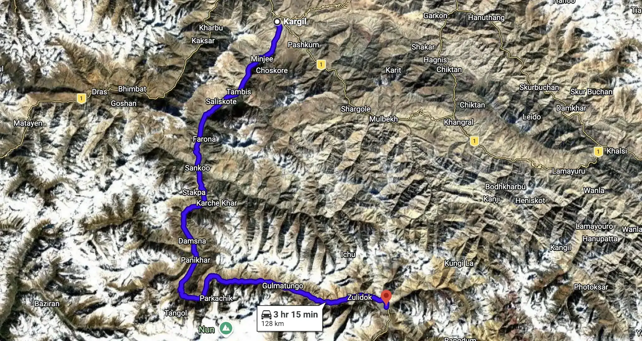
The road leaves Kargil’s bustle and climbs the Suru past apricot villages and Shia hamlets until the twin 7,000ers of Nun and Kun rear over the Parkachik glacier, which spills to the very edge of the tarmac. Beyond Parkachik the metalled road gives out and the valley empties into high, empty moorland, ending at Rangdum — a lonely Buddhist outpost with an 18th-century gompa on a hill and nothing past it but Pensi La and Zanskar.
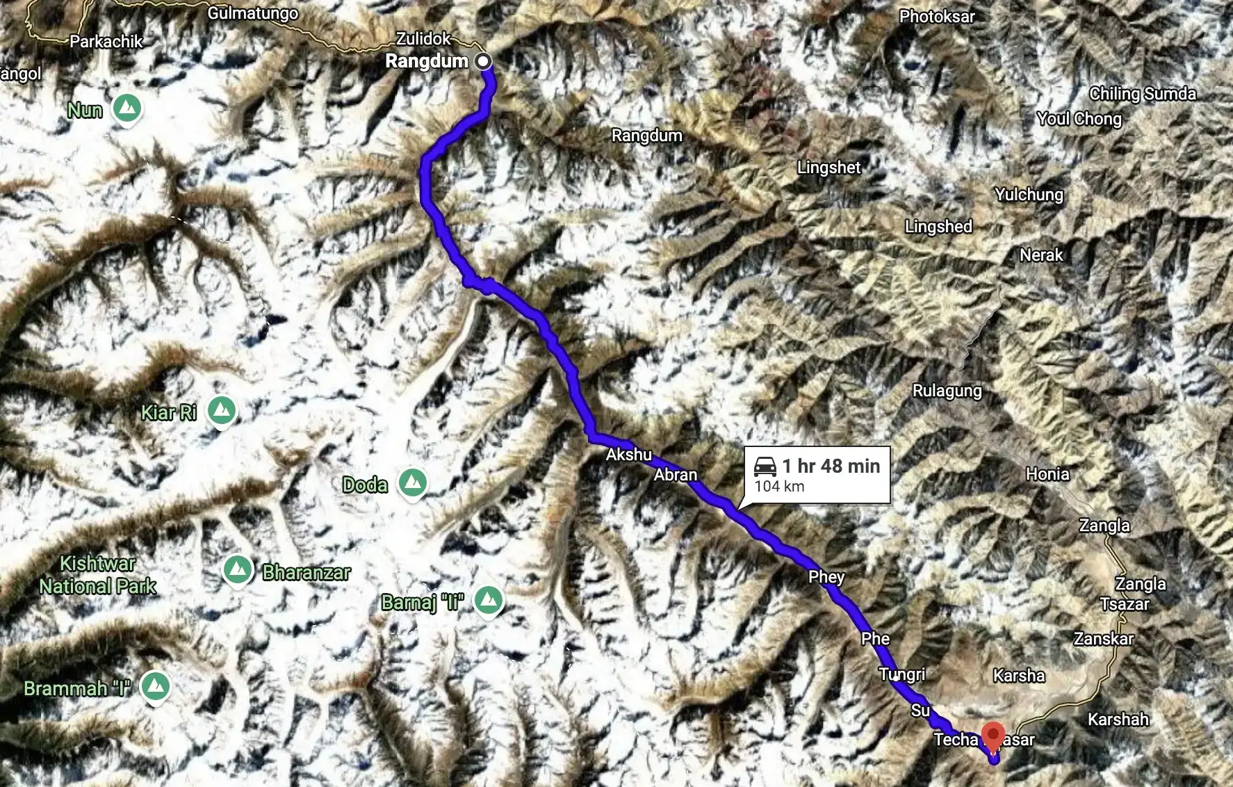
The geological centrepiece. You leave the Suru Valley behind at Rangdum and climb a long, unhurried grade to Pensi La (14,436 ft), the watershed that gates the whole of Zanskar. Over the top the road runs straight past the Drang Drung — a 23-km river of ice, likely the largest glacier in Ladakh after the Siachen — before dropping through the Stod (Doda) valley it feeds, past the oldest monastery in the region, to Padum.
A deliberate breather in the heart of Zanskar. You’ve earned it and your body needs it — this is the acclimatization buffer before the valley’s high southern exit. Short, unhurried riding on the valley floor, linking the two greatest gompas in Zanskar, the old town, and 8th-century rock carvings. Ride slow, drink water, sleep well.
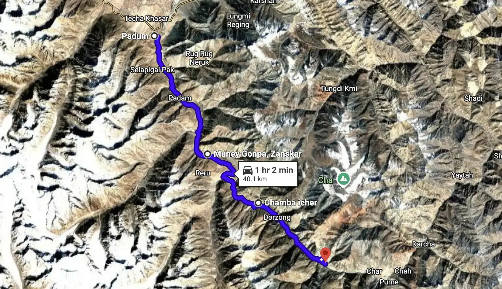
The Zanskar leg most riders never reached until now. Fresh NPD blacktop runs south from Padum along the Tsarap Lingti Chu, threading a string of mud-brick villages — Bardan’s cliff gompa, Mune, Reru, Ichar, Cha — to the river confluence at Purne. This is the launch pad for Phugtal, the honeycomb cave monastery built into a cliff around a sacred spring. Remote, cinematic, and until 2023 walk-in only.
The climactic exit. You leave Zanskar the hard, high way — up the Kargyak Chu past the sacred monolith of Gonbo Rangjon, over the freshly black-topped Shinku La (Shingo La) at 16,703 ft, then a long descent down the Jankar gorge to Darcha, where the road finally rejoins the Manali–Leh highway. It is the newest and most dramatic road link into Zanskar, opened to through-traffic only in March 2024. Overnight at Jispa, a genuine hotel town.
The first of the four return passes. You leave the last trees at Jispa, climb the Bhaga gorge past two glacial lakes to Suraj Tal, top out on Baralacha La’s triple watershed at 16,043 ft, then drop into the treeless plains of Sarchu on the Ladakh line. Short on paper, brutal on the body — this is the day the altitude stops being scenery and becomes a medical fact.
The longest, highest and most demanding day of the expedition. From the Sarchu plain you climb the 21 hairpins of the Gata Loops, cross three passes — Nakee La, Lachulung La and, finally, Tanglang La, the second-highest point of the whole trip — then descend the Indus valley past the great monasteries into Leh. Roughly 253 km of raw high-altitude Himalaya in a single ride.
A deliberate buffer in Leh before you fly out. The Manali–Leh highway routinely loses days to weather, landslides and washouts — this day is the insurance that a bad stretch on the way in doesn’t cost you your flight home. If all has gone to plan, it’s a slow, well-earned day: bazaar, café, a last monastery, and the stories.
You say goodbye to the Roof of the World, trading prayer flags and thin air for a spectacular flight back to Delhi. By nightfall, the mountains are behind you and the music is loud—time for a no-holds-barred farewell party. Boots off, stories on repeat, and a proper send-off to an expedition well earned.
Breakfast, airport drop, emotional goodbyes, heartfelt promises to ride again… and a strong chance you’ll book the next expedition within a week.



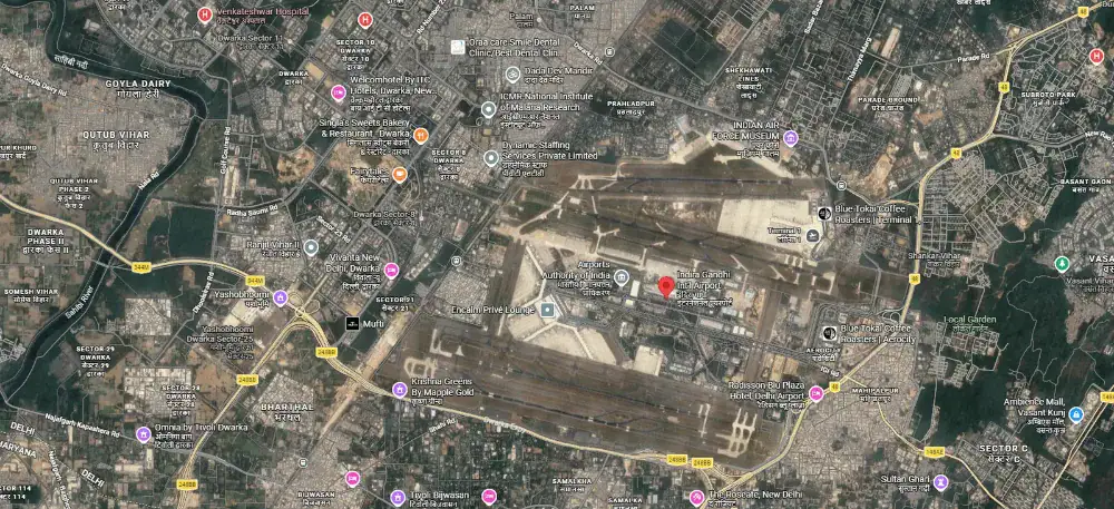
We meet you at Terminal 3 and take you to the group hotel. Delhi sits at roughly 700 ft — the lowest point of the entire expedition, and deliberately so.
First meeting of the full squad, the ride leaders and the mechanic. Route brief, bike allocation preview, and the medical and altitude briefing.
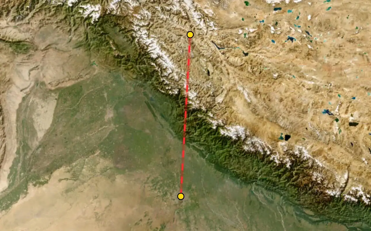
Altitudes: Delhi 700 ft → Leh 11,483 ft. This is the single largest altitude gain of the trip and the reason Day 03 exists.
The approach into Leh runs along the main Himalayan range — Nun Kun and the Zanskar wall on a clear day. Sit on the left side heading north.
We build two full days of acclimatization into the schedule before anyone rides higher. Altitude does not care how fit you are and there is no way to hurry it. Today is complete rest — no walking tours, no bike riding, 3–4 litres of water.
Machines assigned, luggage system explained, and a walk-through of what rides on the support vehicle versus what rides with you.
Net sleeping-altitude gain for the day: zero — you sleep at 11,483 ft, the same as the night before. That is the entire point of this day.
The loop starts and finishes here.
A Peace Pagoda on the Chanspa ridge, begun in 1983 and completed in 1991. It was initiated by the Japanese monk Gyomyo Nakamura of the Nipponzan-Myohoji order and built with Ladakhi volunteers and government support, so it is a Japanese-founded pagoda rather than a Japanese-built one. The Dalai Lama laid its foundation relics in 1985. You ride the road to the gate — the 555 steps from the base are an unnecessary exertion load on day three.
Nine storeys of mud-brick and timber, raised in the early 17th century by King Sengge Namgyal, who ruled from 1616 to 1642. The present Potala in Lhasa went up in 1645, in the same architectural tradition. Parts of the interior are dark and the building is still under ASI restoration, so carry a torch and watch your footing.
The highest point in Leh town, on the crag above the palace, holding a three-storey gold Maitreya. The last stretch is a steep foot climb on rough steps, at the day's altitude maximum. Optional for anyone feeling the altitude.
The Indian Army's museum and memorial for this sector — Kargil, Siachen, the Wall of Heroes in black granite, and an outdoor park of tanks and artillery. Established 1986, renovated 2015.
Gelugpa gompa on a hillock beside Leh airport, looking out over the Indus valley, founded in the 11th century and taken over by the Yellow Hats in the 15th. Its giant Vajrabhairava is unveiled only at the Gustor festival. Take it on the way out, not on the way back.
Built by the Indian Army around a boulder said to carry the impression of Guru Nanak's body from his 1517 passage through Ladakh. The boulder resurfaced during construction of the Leh–Nimmu road in the 1970s and could not be moved. Free langar for every visitor regardless of faith — and the only verified toilets on the loop.
A gravity hill, not a magnetic one. The horizon is obscured by the surrounding slopes so the brain misreads a shallow descent as a climb — the road is going downhill the entire time, and our own elevation profile confirms it. It is a live highway, so this is a stop to look at, not to experiment on.
Where the Zanskar comes out of its gorge and meets the Indus, two rivers of visibly different colour running side by side before they mix. Which is which, and how strong the contrast is, changes with the season and the silt the Zanskar is carrying. In deep winter the Zanskar freezes and becomes the Chadar trek — though the walk itself starts upstream at Chilling, not here.
Back on NH1 over the rise at Pathar Sahib and down into town. Final gear check, final instructions.
Distances measured from Leh, all on NH1. Sealed tarmac for effectively the whole route, subject to BRO roadworks — technically the easiest surface of any Ladakh riding day.
The whole day runs on NH1, the Srinagar–Leh highway.
The Sikh shrine built by the Indian Army around Guru Nanak's boulder. Free meal for anyone who wants one, and the best toilets for the next hundred kilometres.
The gravity hill. Our elevation profile shows the road dropping through here — it is going down the whole way.
The two rivers meeting in visibly different colours. In winter this is the turn-off for the Chadar trek — the walk on the frozen river itself starts at Chilling, some 30 km further up the Zanskar.
The practical breakfast halt out of Leh.
A hilltop monastery standing over the ruins of the old town — a political and cultural centre of early Ladakh, named repeatedly in the Ladakhi Chronicles. A palace stood here in the 15th century; the monastery complex was built for the Namgyal rulers in 1680 and holds three Maitreya temples — Chamchung, Chamba Lakhang and Serzang.
Not on the highway — you cross the Indus at Saspol bridge to the south bank. Alchi holds some of the oldest surviving murals in Ladakh, painted by Kashmiri artists in the 12th to early 13th century — the traditional attribution to Rinchen Zangpo in the 11th is not supported by the inscriptions — in a style so ornate it has been called baroque, preserving Kashmiri Buddhist iconography that no longer survives in Kashmir itself. Unusually for Ladakh it sits on the valley floor, not a crag. Photography inside is strictly prohibited to protect the pigments, and it is enforced.
Riverside tea halt on the long descent along the Indus.
The low point of the day, about 400 m below Leh. A pump is reported here but it does not appear in the official IndianOil database, so treat it as probable rather than guaranteed — the same caution applies coming the other way on Day 09. From here it is 126 km and two passes — Fotu La at 13,478 ft and Namika La at 12,139 ft — to the next confirmed IndianOil pump, which is at Kargil. Ladakh pumps can run dry in season, so the support vehicle carries reserve.
The moonland is not folklore. Lamayuru sits in a palaeolake basin: a tectonically triggered landslide dammed the river in the Late Pleistocene, and the lake laid down over 330 ft of pale silts and clays with annual varves from around 35,000 years ago until roughly a thousand years back. When it drained, those soft pale sediments eroded into badlands — that is the lunar look. The monastery's oldest building dates to the 10th–11th century and is attributed to Rinchen Zangpo; by Drikung tradition it was founded by Naropa, who dried the lake up.
The highest point on the entire Srinagar–Leh highway, and we checked rather than repeating the claim: we profiled the other half of the highway and Zoji La tops out at about 11,575 ft. Fotu La beats it by roughly 1,900 ft. A broad wind-scoured saddle with chortens, reached by the long switchback climb out of Lamayuru — the signature riding of the day.
Village on the valley floor between the two passes, with an army presence. Do not photograph installations or convoys.
The Pillar of the Sky, from the Tibetan gnam gyi ka la. The second and lower of the two passes — a rounded ochre saddle with chortens, and the classic photograph for the two-pass set.
A colossal four-armed Maitreya cut into an isolated rock outcrop right beside the highway, roughly 25 to 30 feet high. Dates from the 7th to the 12th century have been proposed, with recent scholarship favouring the late 10th or early 11th — there is no contemporary inscription, so the dating rests on style alone. The stupa in its headdress is what identifies it as Maitreya. Kashmiri in style, which makes it and Alchi a genuinely coherent pair on one day's ride.
Ladakh's second town, on the Suru river, predominantly Muslim in character after a day of Buddhist villages. The Line of Control sits roughly eleven kilometres north — in 1999 Pakistani forces shelled this highway from the ridges above. No photography of military installations, checkposts, convoys or personnel, and no drones. Best workshop capability between Leh and Srinagar.
~126 km / 79 mi measured (OSRM), climbing from Kargil 8,780 ft to Rangdum 11,998 ft. Good near-flat tarmac to Panikhar (69 km); rough and rocky after Parkachik. No fuel exists anywhere in the Suru valley — fill at Kargil and carry a spare can; the next pump is Karsha, beyond Pensi La.
This is your last certain fuel and last real bazaar before Padum. Kargil town has working IndianOil/HP pumps, but there is nothing at all up the Suru valley beyond it — no confirmed outlet sells reliable fuel up-valley — so fill the tank and carry a spare can. Draw cash too; the ATMs stop here.
Forty-odd kilometres of good, near-flat tarmac bring you to Sankoo, the tehsil headquarters and the green heart of the lower valley: apricot and willow, and a largely Shia Purig-Balti people of Tibetan descent. It is the obvious tea-and-legs stop, and about the last place your phone works — 4G effectively ends here. The Kartse Khar rock-cut Maitreya Buddha is a short detour nearby if you have time.
Panikhar sits at the foot of the Nun-Kun massif and is the classic basecamp for the peaks and the trekking gateway to Zanskar. Nun (23,409 ft) and Kun (23,219 ft) — the highest summits of the former J&K — show themselves from here and from Parkachik La above the village. Beds are homestays and wood-built lodges plus a government tourist bungalow, though the JKTDC bungalow has been reported closed in some seasons, so don't count on it.
The set-piece of the day: the Parkachik glacier tumbles off Nun-Kun's slopes down to the Suru, an ice-fall whose front wall runs to roughly 300 ft and calves without warning; a suspension footbridge crosses the river to the toe if you want a closer look. It is retreating fast — a Cambridge glaciology study documents the pull-back — so what you see is smaller each year. J&K Tourism runs basic Alpine Huts here, and this is where the good road ends.
From Parkachik the metal gives out and the track turns rough, rocky and slow — reckon 3-4 hours for the last ~40 km to Rangdum. Expect glacier-fed streams washing over the road; they run higher in the afternoon melt, so cross early where you can. This loose surface and afternoon water are the real hazard of the day — don't ride it tired.
The valley empties into stark, flat moorland ringed by crags, and the first houses you meet — Yuldo (Juldo) and Julidok — are suddenly Buddhist, socially and culturally part of Zanskar rather than the Shia Suru behind you. These tiny hamlets are the last inhabited ground and the lay support for Rangdum monastery. Prayer flags replace the mosque; you have crossed a quiet cultural border.
Road's-end for the day: a bleak, handsome bowl at 11,998 ft where crops barely ripen in the short summer. Beds are a village guesthouse (reported clean and decent, with meals), a few homestays, and summer tent/parachute camps roughly 2 km on — carry your own essentials, as provisions are minimal and there is no reliable network. It's a hard first night at real altitude, so hydrate and go easy.
About 5 km off the main road, the 18th-century Rangdum Gompa (Gelugpa) sits atop an isolated hillock like a small fort, home to around thirty monks; it was founded under King Tsewang Namgyal II (1753–82). A fine evening or next-morning visit; ask before photographing monks or interiors.
~105 km / 65 mi, Rangdum 11,998 ft over Pensi La 14,436 ft down to Padum 11,499 ft. Road open only ~May–October; long stretches from Pensi La down to near Padum are rough, unmetalled dirt (blacktop only near Padum) — allow a full driving day. Fuel: fill the reliable IndianOil pump at Karsha; Padum's own pump is frequently non-operational.
The morning start, on the wide gravel flats where the Suru River braids beneath the Rangdum Gompa on its isolated hillock. This is the last settlement of the Suru Valley; ahead lies nothing but the climb to the pass and, beyond it, Buddhist Zanskar. Top up water — there are no services until Padum.
The Gateway to Zanskar and the high point of the day — a broad, gently-won saddle rather than a knife-edge pass, reached by a climb that never turns steep. Pensi La is a true watershed: west, meltwater drains to the Suru and the Indus at Kargil; east, it feeds the Stod (Doda) that you now follow into Zanskar. Two small summit tarns, Ta Tso and Lang Tso, sit just off the road and can stay frozen into early June.
The reason the leg carries the tagline. A short descent from the pass and the Drang Drung fills the valley — a 23-km valley glacier winding down from the Doda massif, the source of the Stod (Doda) river. Read the geology straight off the landscape: the curving dark stripes are medial and lateral moraines carried on the ice, the trough below is a textbook glacial U-valley, and the grey meltwater braiding out of the snout is the river you will trace all the way to Padum. Untouched, unfenced, and directly roadside.
After the barren glacial upper valley, the first irrigated fields and poplar windbreaks appear — the small farming hamlets of the upper Stod. A natural place to break and take chai after the roughest, most remote stretch of dirt road. The transition from ice-and-rock to green barley terraces marks your true entry into inhabited Zanskar.
A roadside Zanskari village on the floor of the widening Padum plain, where the blacktop reappears and the driving eases. Fields of barley and mustard, mani walls and whitewashed chortens signal that you are now in the settled heart of the valley, minutes from Sani.
Sani is thought to be the oldest religious site in Ladakh and Zanskar. Its heart is the Kanika Chorten, an unusual stupa attributed to the Kushan emperor Kanishka, set in a walled, tree-shaded compound on the flat valley floor — unusual for a Zanskari gompa, which normally clings to cliffs. The great Indian yogi Naropa is said to have meditated in a cell beside the chorten. It belongs to the Drukpa Kagyu order.
Journey's end: the administrative centre of Zanskar and the largest settlement for days in any direction. Padum has hotels, homestays and restaurants, a mechanic, a post office and, since 2020–2023, Jio and Airtel mobile coverage alongside the older BSNL. Treat cash and fuel as scarce: ATMs exist but run dry, and the town's petrol pump is often out of order — which is why the day's real fuel stop is Karsha.
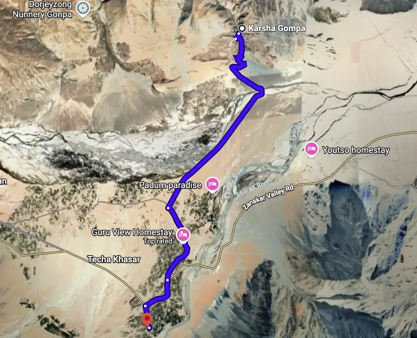
The dependable fuel stop for the whole region — IndianOil's Zanskar Filling Station at Karsha (petrol and diesel, listed 06:00–22:00), reached on a short run northwest across the Doda from Padum. Fill here rather than gambling on Padum's own pump. Karsha also holds Zanskar's largest and most spectacular gompa, tiered up the hillside above.
Why rest here: Padum sits at ~11,499 ft and this is mid-trip — a full day near valley-floor altitude before the exit over Shinku La (16,703 ft) is the best acclimatisation there is. Keep the day flat and easy. Fuel: top off completely today at the Karsha IndianOil pump; south of here toward Purne / Shinku La there is nothing.
A short walk above the old part of Padum sits Stagrimo, a small Drukpa (Kagyu) monastery — Zanskar's two schools meet in a day, Gelugpa at Karsha and Stongdey, Drukpa here. Below it the old town is a knot of mud-brick lanes; Padum today is the administrative centre of Zanskar with roughly 700 inhabitants, basic Indian and Tibetan food in the market, an SBI ATM (carry cash regardless — it fails often), and Jio/Airtel 4G for light use.
About a kilometre out of town toward the Tsarap road stand rock carvings of the five Dhyani Buddhas, held by tradition to be 8th-century and linked to the passage of Guru Padmasambhava through Zanskar. Quiet, weathered, and older than every monastery you'll see today — a fitting close to a slow day.
A conspicuous conical hilltop stupa and small monastery just outside Padum, standing over the point where the Stod (Doda) and Lungnak rivers merge to form the Zanskar. A gentle stretch of the legs and the best single view of the plain you're resting on.
Gelugpa (Yellow Hat), stacked up the hillside above the Stod valley and 'the largest and most important monastery in Zanskar' — about 100 monks. It carries an Avalokiteshvara temple with wall paintings from the era of Rinchen Zangpo (958–1055). Its Gustor masked-dance festival falls in the 11th Tibetan month (usually January), so you won't catch it in season — come for the climb, the views back across the valley to Padum, and the mummified-lama chorten. Fill the tank at the IndianOil pump below the gompa before you ride on.
The valley's second-largest monastic institution — Gelugpa, about 60 monks across seven temples, perched on a hill north of Padum on the Nimmu–Padum road. It is traditionally dated to around 1052. The assembly hall is the reason to climb: deities painted on a black ground and outlined in gold. This is the far point of the loop — turn back toward Padum from here.
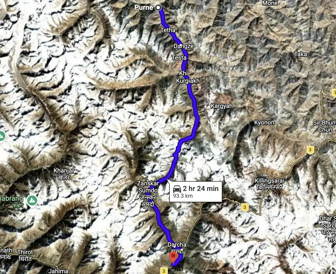
53 km / 33 mi on the new Nimmu–Padum–Darcha (NPD) road (paving completed March 2024); the corridor is fair-weather, not yet all-weather. Padum 11,499 ft, road tops ~12,861 ft at Cha, Purne 12,503 ft. Fuel: fill completely at Padum/Karsha — it is the last pump before the Manali side. No fuel, ATM or reliable signal at Purne or anywhere on this stretch.
Zanskar's administrative hub and your last pump, ATM and cell signal for the rest of the leg. The NPD road replaced the old two-day walk to Purne with a half-day drive. Blacktop is new but the corridor remains fair-weather — the all-weather link waits on the Shinku La tunnel, targeted 2028.
A 17th-century Drukpa Kagyu monastery perched above the Lungnak (Tsarap) river, affiliated with Stakna near Leh. The Dukhang assembly hall holds grand statues and a cluster of small stupas. First major landmark out of Padum and an easy roadside pull-off.
A tiny farming settlement with its own small monastery, strung along the widening river terraces. Fields of barley and green willow break the ochre canyon walls — classic Lungnak-valley scenery on the run south toward Reru.
A cluster village on the west bank of the Lungnak, sharing its panchayat with Mune. Basic homestays and a good spot to stretch. From here the valley narrows and the road begins tracing tighter above the gorge.
Before the NPD road pushed through, Ichar was where vehicles stopped and everyone walked. Today the blacktop runs straight past it toward Purne — a marker of just how far access has changed.
A 465-person village on the right bank of the Tsarap and the classic road-head for Phugtal — a 6 km trail from here reaches the monastery in 2–3 hours. A community emergency satellite phone is kept here (no mobile signal). The highest point on the day's drive before the road drops to the confluence.
Journey's end for the day, at the confluence where the Kargyak Chu and Niri Tsarap Chu meet to form the Tsarap River. Purne is the main base — homestays and simple camps, basic food, nothing more; no fuel, ATM or network. From here Phugtal Monastery is a moderate 2–3 hour foot trek up the Tsarap valley.
Founded in the early 15th century by Jangsem Sherap Zangpo, a disciple of Tsongkhapa, Phugtal is built into a cliffside like a honeycomb around a natural cave and a sacred spring. About 70 monks live in the stacked whitewashed cells clinging to the rock face. Until the NPD road reached Purne it was one of the last Ladakhi monasteries reachable only on foot; even now the final approach is trek-only.
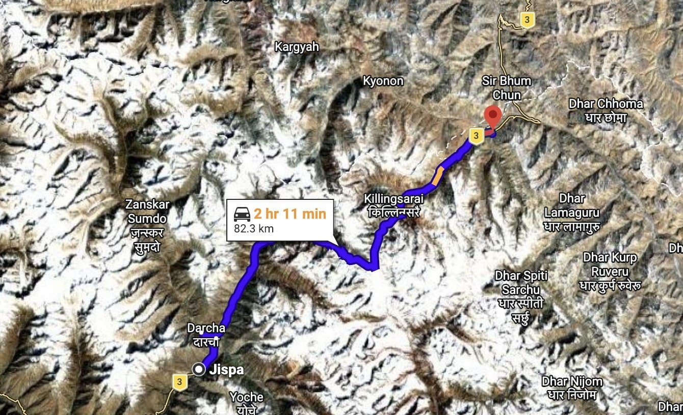
~94 km / 58 mi, and the single biggest FUEL GAP of the trip: there is NO fuel between Purne and Tandi (past Keylong, beyond tonight's halt). You must have filled at Padum/Karsha and be carrying 20–30 L of spare. Shinku La is a 16,703 ft pass with real snow, ice, river-crossing and flash-flood exposure — cross early, before midday snowmelt swells the fords. In peak season (Jul–Sep) motorcycles cross freely; in shoulder-season snow the BRO restricts the top to 4x4 only.
A cluster of homestays at the confluence of the Tsarap and Kargyak rivers, and your last civilisation before the pass. Leave at first light: today's fords run low and manageable in the cold morning and turn into aggressive glacial torrents by afternoon. There is no petrol here or anywhere ahead — your tank should have been filled at Padum/Karsha yesterday.
A green barley oasis on the right bank of the Kargyak Chu, at 13,517 ft one of the highest permanently inhabited villages in Ladakh. Stop for salt tea and a last human welcome. From here the valley narrows and the surface turns to raw BRO track under active black-topping.
The trip's great photo prize: a sheer, free-standing pyramid of dark rock rising straight off the valley floor. Its name means 'Throne of Gonbo' — locals revere it as the seat of Mahakala and it is a holy mountain, so riders stop to shoot, not to scramble. It stands roughly 12–16 km south of Kargyak, right beside the road.
A bleak confluence at 14,633 ft where the real ascent begins. From here it is a steep 10.5 km haul to the pass, gaining ~2,067 ft. Expect meltwater stream crossings on the approach — hit them before the sun does its work.
The exit pass and the day's high point. The BRO and survey data put it at 16,703 ft; the summit signboard reads 16,615.5 ft and SRTM returns ~16,529 ft — treat 16,703 ft as the working figure and note the variance. The BRO black-topped the full road (through-completed March 2024); a 4.1 km twin-tube tunnel for all-weather access is targeted for August 2028. Twenty minutes maximum at the top — photos, prayer flags, then keep moving.
The southern descent drops fast through the Jankar Nala gorge past Ramjak and Zanskar Sumdo. This is the flash-flood corridor: in early August 2024 a flood destroyed a bridge 14 km from Darcha and shut the road for days. Ride the gorge steadily and don't linger in the narrows.
Back on tarmac and back on the grid. Darcha, 11,024 ft, is the northernmost permanent village in Himachal on the Manali–Leh highway, and every vehicle must stop at its police checkpost for ID and registration — carry documents to hand. A new steel bridge spans the Bhaga–Jankar confluence here.
Tonight's halt on the banks of the Bhaga, ~7 km south of Darcha. Jispa is the accommodation hub of upper Lahaul with real hotels, and at ~10,892 ft it is a far kinder sleeping altitude than Sarchu. Hot food, a proper bed, and the hardest pass of the trip behind you.
~79 km / 49 mi, net climb Jispa 10,892 ft → Baralacha La 16,043 ft → sleep at Sarchu 14,075 ft. AMS WARNING: Sarchu is notorious — you sleep ~3,281 ft higher than Jispa after crossing 16,043 ft, the classic 'climb high, sleep too high' trap; symptoms peak overnight. Hydrate, no alcohol, keep the first night mellow. Fuel: zero official fuel; only unreliable 'black' fuel from jerry cans at Zingzing Bar / Sarchu at a premium. No mobile network past Jispa.
Darcha is the last real settlement of the day and the point where the Zanskar trekking trail peels off across the Bhaga. A cluster of dhabas and a police check post sit by the bridge; this is the final place with anything resembling a village before the high desert. Fill water and eat — services thin fast from here.
A small teal glacial lake at roughly 12,336 ft, set in almost lunar rock a short way north of Darcha. A quick photo halt rather than a destination — calm water, no facilities. Early in the season it can still be part-frozen.
A row of seasonal dhaba tents at about 14,009 ft and effectively the last place to get hot soup, maggi and chai before the pass. It's also one of the few points selling unofficial 'black' fuel from cans if you've misjudged your tank — at a steep markup. Beyond here the climb to Baralacha begins in earnest and early-season water crossings are common.
Sitting just below the pass at close to 16,043 ft, Suraj Tal is the source of the Bhaga River and is commonly ranked among India's highest lakes. On a clear day the water turns an improbable blue-green; in June it is still ringed with ice. Pilgrims consider a dip purifying, though at this altitude the cold is genuinely dangerous — admire it, don't swim it.
A genuine hydrological knot — a triple watershed where the Bhaga, Chandra and Yunam rivers all rise. Snow lingers year-round and fresh falls happen even in June; summer temperatures swing from +3 to -10 °C with zero network. Don't linger long at the top — photos, then keep moving to shed altitude.
A scatter of parachute-tent dhabas and camps on the plain north of the pass at about 15,092 ft, one of the highest tented halts on the whole highway. A possible lunch or emergency stop. Bleak, wind-scoured and beautiful.
Sarchu straddles the Himachal Pradesh–Ladakh boundary at ~14,075 ft and has no permanent population — only seasonal tented camps that vanish each winter. It is infamous for altitude sickness: riders arrive having gained huge height in one day and then sleep high, so headaches and worse tend to hit overnight. Hydrate hard, skip alcohol, keep the first night mellow, and know the nearest help is hours away.
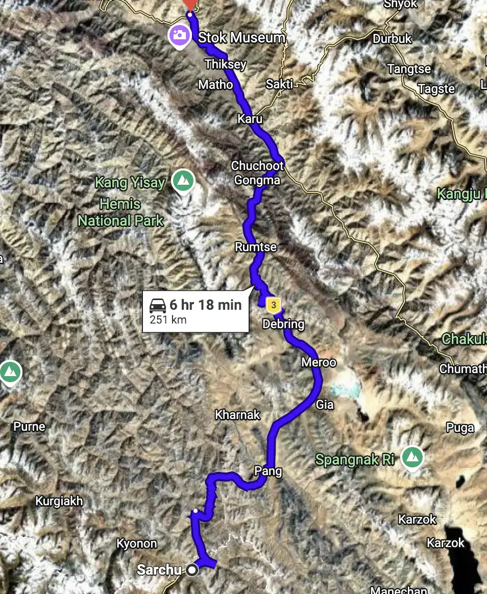
~253 km / 157 mi (OSRM), across THREE passes, Sarchu 14,075 ft → Tanglang La 17,480 ft → Leh 11,483 ft. THE LONGEST DAY: budget 9–11 hrs riding + stops; start at first light to clear Tanglang La before afternoon wind and to reach Leh in daylight. Fuel: the first reliable pump is Karu (~226 km, near Leh); Pang sells only unofficial 'black' fuel, often adulterated — carry a full tank plus spare. Cold, fatigue and cumulative altitude are the real hazards; keep summit stops short.
Your camp sits on the Sarchu plain beside the Tsarap Chu, a state-border halt with an army camp nearby. It is one of the most demanding places to sleep on the highway, so many riders wake groggy — hydrate, eat lightly and roll out at first light for the long haul north.
Twenty-one tight hairpin bends stack up the mountainside, climbing roughly 1,444–1,640 ft in about 7 km from the 13,747 ft valley floor. A well-known folk legend tells of the ghost of a stranded road-worker who died of thirst here, whom truckers leave water bottles to appease — treat this strictly as roadside folklore, not history. A genuinely tiring warm-up for the passes to come.
The first of the day's three passes, topping out at 15,548 ft just above the Gata Loops — a short, sharp crest of prayer flags before the road drops toward Whisky Nala. A quick photo halt only; the higher passes ahead demand your energy.
Between Nakee La and Lachulung La a small cluster of parachute-tent dhabas sits by a seasonal stream — realistically your only chance to eat or drink between Sarchu and Pang. They run only in season and take cash only. Warm up with chai and noodles; the next pass is the highest so far.
Your first crossing above 16,404 ft today, at 16,598 ft. An independent SRTM reading at the summit returned 16,624 ft — bracketing the published figure almost exactly, so this height is solid. Eroded mud pinnacles line the descent. Keep the halt short; at this altitude every extra minute standing costs you.
Pang sits at ~15,256 ft with a knot of dhabas, an army transit camp and a striking natural rock arch. It is widely billed as the 'world's highest transit camp' — repeated across sources but not independently certified, so treat it as a well-worn claim, not a record. Hot food and a toilet here; any fuel sold is unofficial and possibly adulterated — do not rely on it.
After Pang the road bursts onto the More (Morey) Plains — a high tableland of roughly 40+ km at about 15,420 ft, an almost unreal ribbon of straight tarmac at altitude. It is the fastest, most meditative stretch of the day, but utterly exposed; the headwind and cold bite hard.
At Debring a side road heads west to Tso Kar, the fluctuating 'white' salt lake at 14,862 ft. It lies about 30 km off the highway — a genuine detour, worth it for the kiang, Tibetan gazelle and black-necked crane breeding grounds, but only if the schedule allows on this already-long day. Most Sarchu→Leh riders save it for a dedicated day.
The roof of the day and the second-highest point of the whole expedition, signboard 17,480 ft. Satellite readings bracket it honestly: SRTM at the summit returned 17,490 ft — almost dead-on the sign — while older boards claiming ~17,585 ft overstate it. Whatever the exact figure, you are breathing thin air on tired legs — fifteen minutes at the flags, then descend. From here it is all downhill to the Indus.
The first real village after Tanglang La, Rumtse greets you with white chortens and irrigated green fields — the return of habitation after hours of wilderness. It offers simple homestays and tea houses and marks the psychological turning point: the hard climbing is done, the Indus valley run begins.
Upshi is where the highway drops to the Indus and turns into a wide, straight valley run. There is a checkpost here — keep IDs handy — and roadside tea stalls for a last break. From Upshi to Leh it is near-continuous habitation, a gentle, fast finish after the day's high drama.
Karu, ~14 km beyond Upshi, is the first reliable petrol pump on the entire Manali→Leh run — historically there was no genuine fuel for the ~330 km between Tandi and Karu. Top up here regardless of your gauge. This is also where the road to Pangong Tso branches east.
In the last stretch you roll past Thiksey Monastery, the great whitewashed gompa terraced up its hill, and Shey, the old royal palace and its giant Buddha. You are only passing them today on the way in — both get a proper visit on a dedicated Leh-area day — but they are your first sight of classic Ladakhi monastic architecture.
You roll into Leh at ~11,483 ft after roughly 253 km, three passes and the single biggest day of the expedition. Check in, rehydrate hard and let the body recover — the descent from Tanglang La brings welcome oxygen but the day's cumulative altitude load is heavy. You have earned the hot meal and the still bed.
Why this day exists: it is the schedule's shock-absorber. If the ride ran clean you spend it at leisure in Leh; if a pass or the Shinku La road cost you a day, this is where that time was borrowed from. Nothing is scheduled — recover, shop, and repack.
Main Bazaar and the German Bakery cafés, the Central Asian Museum, a quiet return to Shanti Stupa at sunset, or simply a day off the bike. Optional short rides to Thiksey or Shey (passed on the way in) are easy add-ons for anyone still hungry for the road.
Sort gear for the flight, settle the machines with the mechanic, and confirm airport transfer times — Leh flights leave very early and weather cancellations happen.
Leh airport clears early and weather cancellations happen — the transfer leaves the hotel well before dawn.
Certificates, the ride video, and the stories that have grown considerably since Khardung La.
We run the transfer to suit your flight. Bear in mind Delhi traffic and international check-in requirements.
We meet you at Terminal 3 and take you to the group hotel. Delhi sits at roughly 700 ft — the lowest point of the entire expedition, and deliberately so.
First meeting of the full squad, the ride leaders and the mechanic. Route brief, bike allocation preview, and the medical and altitude briefing.
Altitudes: Delhi 700 ft → Leh 11,483 ft. This is the single largest altitude gain of the trip and the reason Day 03 exists.
The approach into Leh runs along the main Himalayan range — Nun Kun and the Zanskar wall on a clear day. Sit on the left side heading north.
We build two full days of acclimatization into the schedule before anyone rides higher. Altitude does not care how fit you are and there is no way to hurry it. Today is complete rest — no walking tours, no bike riding, 3–4 litres of water.
Machines assigned, luggage system explained, and a walk-through of what rides on the support vehicle versus what rides with you.
Net sleeping-altitude gain for the day: zero — you sleep at 11,483 ft, the same as the night before. That is the entire point of this day.
The loop starts and finishes here.
A Peace Pagoda on the Chanspa ridge, begun in 1983 and completed in 1991. It was initiated by the Japanese monk Gyomyo Nakamura of the Nipponzan-Myohoji order and built with Ladakhi volunteers and government support, so it is a Japanese-founded pagoda rather than a Japanese-built one. The Dalai Lama laid its foundation relics in 1985. You ride the road to the gate — the 555 steps from the base are an unnecessary exertion load on day three.
Nine storeys of mud-brick and timber, raised in the early 17th century by King Sengge Namgyal, who ruled from 1616 to 1642. The present Potala in Lhasa went up in 1645, in the same architectural tradition. Parts of the interior are dark and the building is still under ASI restoration, so carry a torch and watch your footing.
The highest point in Leh town, on the crag above the palace, holding a three-storey gold Maitreya. The last stretch is a steep foot climb on rough steps, at the day's altitude maximum. Optional for anyone feeling the altitude.
The Indian Army's museum and memorial for this sector — Kargil, Siachen, the Wall of Heroes in black granite, and an outdoor park of tanks and artillery. Established 1986, renovated 2015.
Gelugpa gompa on a hillock beside Leh airport, looking out over the Indus valley, founded in the 11th century and taken over by the Yellow Hats in the 15th. Its giant Vajrabhairava is unveiled only at the Gustor festival. Take it on the way out, not on the way back.
Built by the Indian Army around a boulder said to carry the impression of Guru Nanak's body from his 1517 passage through Ladakh. The boulder resurfaced during construction of the Leh–Nimmu road in the 1970s and could not be moved. Free langar for every visitor regardless of faith — and the only verified toilets on the loop.
A gravity hill, not a magnetic one. The horizon is obscured by the surrounding slopes so the brain misreads a shallow descent as a climb — the road is going downhill the entire time, and our own elevation profile confirms it. It is a live highway, so this is a stop to look at, not to experiment on.
Where the Zanskar comes out of its gorge and meets the Indus, two rivers of visibly different colour running side by side before they mix. Which is which, and how strong the contrast is, changes with the season and the silt the Zanskar is carrying. In deep winter the Zanskar freezes and becomes the Chadar trek — though the walk itself starts upstream at Chilling, not here.
Back on NH1 over the rise at Pathar Sahib and down into town. Final gear check, final instructions.
Distances measured from Leh, all on NH1. Sealed tarmac for effectively the whole route, subject to BRO roadworks — technically the easiest surface of any Ladakh riding day.
The whole day runs on NH1, the Srinagar–Leh highway.
The Sikh shrine built by the Indian Army around Guru Nanak's boulder. Free meal for anyone who wants one, and the best toilets for the next hundred kilometres.
The gravity hill. Our elevation profile shows the road dropping through here — it is going down the whole way.
The two rivers meeting in visibly different colours. In winter this is the turn-off for the Chadar trek — the walk on the frozen river itself starts at Chilling, some 30 km further up the Zanskar.
The practical breakfast halt out of Leh.
A hilltop monastery standing over the ruins of the old town — a political and cultural centre of early Ladakh, named repeatedly in the Ladakhi Chronicles. A palace stood here in the 15th century; the monastery complex was built for the Namgyal rulers in 1680 and holds three Maitreya temples — Chamchung, Chamba Lakhang and Serzang.
Not on the highway — you cross the Indus at Saspol bridge to the south bank. Alchi holds some of the oldest surviving murals in Ladakh, painted by Kashmiri artists in the 12th to early 13th century — the traditional attribution to Rinchen Zangpo in the 11th is not supported by the inscriptions — in a style so ornate it has been called baroque, preserving Kashmiri Buddhist iconography that no longer survives in Kashmir itself. Unusually for Ladakh it sits on the valley floor, not a crag. Photography inside is strictly prohibited to protect the pigments, and it is enforced.
Riverside tea halt on the long descent along the Indus.
The low point of the day, about 400 m below Leh. A pump is reported here but it does not appear in the official IndianOil database, so treat it as probable rather than guaranteed — the same caution applies coming the other way on Day 09. From here it is 126 km and two passes — Fotu La at 13,478 ft and Namika La at 12,139 ft — to the next confirmed IndianOil pump, which is at Kargil. Ladakh pumps can run dry in season, so the support vehicle carries reserve.
The moonland is not folklore. Lamayuru sits in a palaeolake basin: a tectonically triggered landslide dammed the river in the Late Pleistocene, and the lake laid down over 330 ft of pale silts and clays with annual varves from around 35,000 years ago until roughly a thousand years back. When it drained, those soft pale sediments eroded into badlands — that is the lunar look. The monastery's oldest building dates to the 10th–11th century and is attributed to Rinchen Zangpo; by Drikung tradition it was founded by Naropa, who dried the lake up.
The highest point on the entire Srinagar–Leh highway, and we checked rather than repeating the claim: we profiled the other half of the highway and Zoji La tops out at about 11,575 ft. Fotu La beats it by roughly 1,900 ft. A broad wind-scoured saddle with chortens, reached by the long switchback climb out of Lamayuru — the signature riding of the day.
Village on the valley floor between the two passes, with an army presence. Do not photograph installations or convoys.
The Pillar of the Sky, from the Tibetan gnam gyi ka la. The second and lower of the two passes — a rounded ochre saddle with chortens, and the classic photograph for the two-pass set.
A colossal four-armed Maitreya cut into an isolated rock outcrop right beside the highway, roughly 25 to 30 feet high. Dates from the 7th to the 12th century have been proposed, with recent scholarship favouring the late 10th or early 11th — there is no contemporary inscription, so the dating rests on style alone. The stupa in its headdress is what identifies it as Maitreya. Kashmiri in style, which makes it and Alchi a genuinely coherent pair on one day's ride.
Ladakh's second town, on the Suru river, predominantly Muslim in character after a day of Buddhist villages. The Line of Control sits roughly eleven kilometres north — in 1999 Pakistani forces shelled this highway from the ridges above. No photography of military installations, checkposts, convoys or personnel, and no drones. Best workshop capability between Leh and Srinagar.
~126 km / 79 mi measured (OSRM), climbing from Kargil 8,780 ft to Rangdum 11,998 ft. Good near-flat tarmac to Panikhar (69 km); rough and rocky after Parkachik. No fuel exists anywhere in the Suru valley — fill at Kargil and carry a spare can; the next pump is Karsha, beyond Pensi La.
This is your last certain fuel and last real bazaar before Padum. Kargil town has working IndianOil/HP pumps, but there is nothing at all up the Suru valley beyond it — no confirmed outlet sells reliable fuel up-valley — so fill the tank and carry a spare can. Draw cash too; the ATMs stop here.
Forty-odd kilometres of good, near-flat tarmac bring you to Sankoo, the tehsil headquarters and the green heart of the lower valley: apricot and willow, and a largely Shia Purig-Balti people of Tibetan descent. It is the obvious tea-and-legs stop, and about the last place your phone works — 4G effectively ends here. The Kartse Khar rock-cut Maitreya Buddha is a short detour nearby if you have time.
Panikhar sits at the foot of the Nun-Kun massif and is the classic basecamp for the peaks and the trekking gateway to Zanskar. Nun (23,409 ft) and Kun (23,219 ft) — the highest summits of the former J&K — show themselves from here and from Parkachik La above the village. Beds are homestays and wood-built lodges plus a government tourist bungalow, though the JKTDC bungalow has been reported closed in some seasons, so don't count on it.
The set-piece of the day: the Parkachik glacier tumbles off Nun-Kun's slopes down to the Suru, an ice-fall whose front wall runs to roughly 300 ft and calves without warning; a suspension footbridge crosses the river to the toe if you want a closer look. It is retreating fast — a Cambridge glaciology study documents the pull-back — so what you see is smaller each year. J&K Tourism runs basic Alpine Huts here, and this is where the good road ends.
From Parkachik the metal gives out and the track turns rough, rocky and slow — reckon 3-4 hours for the last ~40 km to Rangdum. Expect glacier-fed streams washing over the road; they run higher in the afternoon melt, so cross early where you can. This loose surface and afternoon water are the real hazard of the day — don't ride it tired.
The valley empties into stark, flat moorland ringed by crags, and the first houses you meet — Yuldo (Juldo) and Julidok — are suddenly Buddhist, socially and culturally part of Zanskar rather than the Shia Suru behind you. These tiny hamlets are the last inhabited ground and the lay support for Rangdum monastery. Prayer flags replace the mosque; you have crossed a quiet cultural border.
Road's-end for the day: a bleak, handsome bowl at 11,998 ft where crops barely ripen in the short summer. Beds are a village guesthouse (reported clean and decent, with meals), a few homestays, and summer tent/parachute camps roughly 2 km on — carry your own essentials, as provisions are minimal and there is no reliable network. It's a hard first night at real altitude, so hydrate and go easy.
About 5 km off the main road, the 18th-century Rangdum Gompa (Gelugpa) sits atop an isolated hillock like a small fort, home to around thirty monks; it was founded under King Tsewang Namgyal II (1753–82). A fine evening or next-morning visit; ask before photographing monks or interiors.
~105 km / 65 mi, Rangdum 11,998 ft over Pensi La 14,436 ft down to Padum 11,499 ft. Road open only ~May–October; long stretches from Pensi La down to near Padum are rough, unmetalled dirt (blacktop only near Padum) — allow a full driving day. Fuel: fill the reliable IndianOil pump at Karsha; Padum's own pump is frequently non-operational.
The morning start, on the wide gravel flats where the Suru River braids beneath the Rangdum Gompa on its isolated hillock. This is the last settlement of the Suru Valley; ahead lies nothing but the climb to the pass and, beyond it, Buddhist Zanskar. Top up water — there are no services until Padum.
The Gateway to Zanskar and the high point of the day — a broad, gently-won saddle rather than a knife-edge pass, reached by a climb that never turns steep. Pensi La is a true watershed: west, meltwater drains to the Suru and the Indus at Kargil; east, it feeds the Stod (Doda) that you now follow into Zanskar. Two small summit tarns, Ta Tso and Lang Tso, sit just off the road and can stay frozen into early June.
The reason the leg carries the tagline. A short descent from the pass and the Drang Drung fills the valley — a 23-km valley glacier winding down from the Doda massif, the source of the Stod (Doda) river. Read the geology straight off the landscape: the curving dark stripes are medial and lateral moraines carried on the ice, the trough below is a textbook glacial U-valley, and the grey meltwater braiding out of the snout is the river you will trace all the way to Padum. Untouched, unfenced, and directly roadside.
After the barren glacial upper valley, the first irrigated fields and poplar windbreaks appear — the small farming hamlets of the upper Stod. A natural place to break and take chai after the roughest, most remote stretch of dirt road. The transition from ice-and-rock to green barley terraces marks your true entry into inhabited Zanskar.
A roadside Zanskari village on the floor of the widening Padum plain, where the blacktop reappears and the driving eases. Fields of barley and mustard, mani walls and whitewashed chortens signal that you are now in the settled heart of the valley, minutes from Sani.
Sani is thought to be the oldest religious site in Ladakh and Zanskar. Its heart is the Kanika Chorten, an unusual stupa attributed to the Kushan emperor Kanishka, set in a walled, tree-shaded compound on the flat valley floor — unusual for a Zanskari gompa, which normally clings to cliffs. The great Indian yogi Naropa is said to have meditated in a cell beside the chorten. It belongs to the Drukpa Kagyu order.
Journey's end: the administrative centre of Zanskar and the largest settlement for days in any direction. Padum has hotels, homestays and restaurants, a mechanic, a post office and, since 2020–2023, Jio and Airtel mobile coverage alongside the older BSNL. Treat cash and fuel as scarce: ATMs exist but run dry, and the town's petrol pump is often out of order — which is why the day's real fuel stop is Karsha.
The dependable fuel stop for the whole region — IndianOil's Zanskar Filling Station at Karsha (petrol and diesel, listed 06:00–22:00), reached on a short run northwest across the Doda from Padum. Fill here rather than gambling on Padum's own pump. Karsha also holds Zanskar's largest and most spectacular gompa, tiered up the hillside above.
Why rest here: Padum sits at ~11,499 ft and this is mid-trip — a full day near valley-floor altitude before the exit over Shinku La (16,703 ft) is the best acclimatisation there is. Keep the day flat and easy. Fuel: top off completely today at the Karsha IndianOil pump; south of here toward Purne / Shinku La there is nothing.
A short walk above the old part of Padum sits Stagrimo, a small Drukpa (Kagyu) monastery — Zanskar's two schools meet in a day, Gelugpa at Karsha and Stongdey, Drukpa here. Below it the old town is a knot of mud-brick lanes; Padum today is the administrative centre of Zanskar with roughly 700 inhabitants, basic Indian and Tibetan food in the market, an SBI ATM (carry cash regardless — it fails often), and Jio/Airtel 4G for light use.
About a kilometre out of town toward the Tsarap road stand rock carvings of the five Dhyani Buddhas, held by tradition to be 8th-century and linked to the passage of Guru Padmasambhava through Zanskar. Quiet, weathered, and older than every monastery you'll see today — a fitting close to a slow day.
A conspicuous conical hilltop stupa and small monastery just outside Padum, standing over the point where the Stod (Doda) and Lungnak rivers merge to form the Zanskar. A gentle stretch of the legs and the best single view of the plain you're resting on.
Gelugpa (Yellow Hat), stacked up the hillside above the Stod valley and 'the largest and most important monastery in Zanskar' — about 100 monks. It carries an Avalokiteshvara temple with wall paintings from the era of Rinchen Zangpo (958–1055). Its Gustor masked-dance festival falls in the 11th Tibetan month (usually January), so you won't catch it in season — come for the climb, the views back across the valley to Padum, and the mummified-lama chorten. Fill the tank at the IndianOil pump below the gompa before you ride on.
The valley's second-largest monastic institution — Gelugpa, about 60 monks across seven temples, perched on a hill north of Padum on the Nimmu–Padum road. It is traditionally dated to around 1052. The assembly hall is the reason to climb: deities painted on a black ground and outlined in gold. This is the far point of the loop — turn back toward Padum from here.
53 km / 33 mi on the new Nimmu–Padum–Darcha (NPD) road (paving completed March 2024); the corridor is fair-weather, not yet all-weather. Padum 11,499 ft, road tops ~12,861 ft at Cha, Purne 12,503 ft. Fuel: fill completely at Padum/Karsha — it is the last pump before the Manali side. No fuel, ATM or reliable signal at Purne or anywhere on this stretch.
Zanskar's administrative hub and your last pump, ATM and cell signal for the rest of the leg. The NPD road replaced the old two-day walk to Purne with a half-day drive. Blacktop is new but the corridor remains fair-weather — the all-weather link waits on the Shinku La tunnel, targeted 2028.
A 17th-century Drukpa Kagyu monastery perched above the Lungnak (Tsarap) river, affiliated with Stakna near Leh. The Dukhang assembly hall holds grand statues and a cluster of small stupas. First major landmark out of Padum and an easy roadside pull-off.
A tiny farming settlement with its own small monastery, strung along the widening river terraces. Fields of barley and green willow break the ochre canyon walls — classic Lungnak-valley scenery on the run south toward Reru.
A cluster village on the west bank of the Lungnak, sharing its panchayat with Mune. Basic homestays and a good spot to stretch. From here the valley narrows and the road begins tracing tighter above the gorge.
Before the NPD road pushed through, Ichar was where vehicles stopped and everyone walked. Today the blacktop runs straight past it toward Purne — a marker of just how far access has changed.
A 465-person village on the right bank of the Tsarap and the classic road-head for Phugtal — a 6 km trail from here reaches the monastery in 2–3 hours. A community emergency satellite phone is kept here (no mobile signal). The highest point on the day's drive before the road drops to the confluence.
Journey's end for the day, at the confluence where the Kargyak Chu and Niri Tsarap Chu meet to form the Tsarap River. Purne is the main base — homestays and simple camps, basic food, nothing more; no fuel, ATM or network. From here Phugtal Monastery is a moderate 2–3 hour foot trek up the Tsarap valley.
Founded in the early 15th century by Jangsem Sherap Zangpo, a disciple of Tsongkhapa, Phugtal is built into a cliffside like a honeycomb around a natural cave and a sacred spring. About 70 monks live in the stacked whitewashed cells clinging to the rock face. Until the NPD road reached Purne it was one of the last Ladakhi monasteries reachable only on foot; even now the final approach is trek-only.
~94 km / 58 mi, and the single biggest FUEL GAP of the trip: there is NO fuel between Purne and Tandi (past Keylong, beyond tonight's halt). You must have filled at Padum/Karsha and be carrying 20–30 L of spare. Shinku La is a 16,703 ft pass with real snow, ice, river-crossing and flash-flood exposure — cross early, before midday snowmelt swells the fords. In peak season (Jul–Sep) motorcycles cross freely; in shoulder-season snow the BRO restricts the top to 4x4 only.
A cluster of homestays at the confluence of the Tsarap and Kargyak rivers, and your last civilisation before the pass. Leave at first light: today's fords run low and manageable in the cold morning and turn into aggressive glacial torrents by afternoon. There is no petrol here or anywhere ahead — your tank should have been filled at Padum/Karsha yesterday.
A green barley oasis on the right bank of the Kargyak Chu, at 13,517 ft one of the highest permanently inhabited villages in Ladakh. Stop for salt tea and a last human welcome. From here the valley narrows and the surface turns to raw BRO track under active black-topping.
The trip's great photo prize: a sheer, free-standing pyramid of dark rock rising straight off the valley floor. Its name means 'Throne of Gonbo' — locals revere it as the seat of Mahakala and it is a holy mountain, so riders stop to shoot, not to scramble. It stands roughly 12–16 km south of Kargyak, right beside the road.
A bleak confluence at 14,633 ft where the real ascent begins. From here it is a steep 10.5 km haul to the pass, gaining ~2,067 ft. Expect meltwater stream crossings on the approach — hit them before the sun does its work.
The exit pass and the day's high point. The BRO and survey data put it at 16,703 ft; the summit signboard reads 16,615.5 ft and SRTM returns ~16,529 ft — treat 16,703 ft as the working figure and note the variance. The BRO black-topped the full road (through-completed March 2024); a 4.1 km twin-tube tunnel for all-weather access is targeted for August 2028. Twenty minutes maximum at the top — photos, prayer flags, then keep moving.
The southern descent drops fast through the Jankar Nala gorge past Ramjak and Zanskar Sumdo. This is the flash-flood corridor: in early August 2024 a flood destroyed a bridge 14 km from Darcha and shut the road for days. Ride the gorge steadily and don't linger in the narrows.
Back on tarmac and back on the grid. Darcha, 11,024 ft, is the northernmost permanent village in Himachal on the Manali–Leh highway, and every vehicle must stop at its police checkpost for ID and registration — carry documents to hand. A new steel bridge spans the Bhaga–Jankar confluence here.
Tonight's halt on the banks of the Bhaga, ~7 km south of Darcha. Jispa is the accommodation hub of upper Lahaul with real hotels, and at ~10,892 ft it is a far kinder sleeping altitude than Sarchu. Hot food, a proper bed, and the hardest pass of the trip behind you.
~79 km / 49 mi, net climb Jispa 10,892 ft → Baralacha La 16,043 ft → sleep at Sarchu 14,075 ft. AMS WARNING: Sarchu is notorious — you sleep ~3,281 ft higher than Jispa after crossing 16,043 ft, the classic 'climb high, sleep too high' trap; symptoms peak overnight. Hydrate, no alcohol, keep the first night mellow. Fuel: zero official fuel; only unreliable 'black' fuel from jerry cans at Zingzing Bar / Sarchu at a premium. No mobile network past Jispa.
Darcha is the last real settlement of the day and the point where the Zanskar trekking trail peels off across the Bhaga. A cluster of dhabas and a police check post sit by the bridge; this is the final place with anything resembling a village before the high desert. Fill water and eat — services thin fast from here.
A small teal glacial lake at roughly 12,336 ft, set in almost lunar rock a short way north of Darcha. A quick photo halt rather than a destination — calm water, no facilities. Early in the season it can still be part-frozen.
A row of seasonal dhaba tents at about 14,009 ft and effectively the last place to get hot soup, maggi and chai before the pass. It's also one of the few points selling unofficial 'black' fuel from cans if you've misjudged your tank — at a steep markup. Beyond here the climb to Baralacha begins in earnest and early-season water crossings are common.
Sitting just below the pass at close to 16,043 ft, Suraj Tal is the source of the Bhaga River and is commonly ranked among India's highest lakes. On a clear day the water turns an improbable blue-green; in June it is still ringed with ice. Pilgrims consider a dip purifying, though at this altitude the cold is genuinely dangerous — admire it, don't swim it.
A genuine hydrological knot — a triple watershed where the Bhaga, Chandra and Yunam rivers all rise. Snow lingers year-round and fresh falls happen even in June; summer temperatures swing from +3 to -10 °C with zero network. Don't linger long at the top — photos, then keep moving to shed altitude.
A scatter of parachute-tent dhabas and camps on the plain north of the pass at about 15,092 ft, one of the highest tented halts on the whole highway. A possible lunch or emergency stop. Bleak, wind-scoured and beautiful.
Sarchu straddles the Himachal Pradesh–Ladakh boundary at ~14,075 ft and has no permanent population — only seasonal tented camps that vanish each winter. It is infamous for altitude sickness: riders arrive having gained huge height in one day and then sleep high, so headaches and worse tend to hit overnight. Hydrate hard, skip alcohol, keep the first night mellow, and know the nearest help is hours away.
~253 km / 157 mi (OSRM), across THREE passes, Sarchu 14,075 ft → Tanglang La 17,480 ft → Leh 11,483 ft. THE LONGEST DAY: budget 9–11 hrs riding + stops; start at first light to clear Tanglang La before afternoon wind and to reach Leh in daylight. Fuel: the first reliable pump is Karu (~226 km, near Leh); Pang sells only unofficial 'black' fuel, often adulterated — carry a full tank plus spare. Cold, fatigue and cumulative altitude are the real hazards; keep summit stops short.
Your camp sits on the Sarchu plain beside the Tsarap Chu, a state-border halt with an army camp nearby. It is one of the most demanding places to sleep on the highway, so many riders wake groggy — hydrate, eat lightly and roll out at first light for the long haul north.
Twenty-one tight hairpin bends stack up the mountainside, climbing roughly 1,444–1,640 ft in about 7 km from the 13,747 ft valley floor. A well-known folk legend tells of the ghost of a stranded road-worker who died of thirst here, whom truckers leave water bottles to appease — treat this strictly as roadside folklore, not history. A genuinely tiring warm-up for the passes to come.
The first of the day's three passes, topping out at 15,548 ft just above the Gata Loops — a short, sharp crest of prayer flags before the road drops toward Whisky Nala. A quick photo halt only; the higher passes ahead demand your energy.
Between Nakee La and Lachulung La a small cluster of parachute-tent dhabas sits by a seasonal stream — realistically your only chance to eat or drink between Sarchu and Pang. They run only in season and take cash only. Warm up with chai and noodles; the next pass is the highest so far.
Your first crossing above 16,404 ft today, at 16,598 ft. An independent SRTM reading at the summit returned 16,624 ft — bracketing the published figure almost exactly, so this height is solid. Eroded mud pinnacles line the descent. Keep the halt short; at this altitude every extra minute standing costs you.
Pang sits at ~15,256 ft with a knot of dhabas, an army transit camp and a striking natural rock arch. It is widely billed as the 'world's highest transit camp' — repeated across sources but not independently certified, so treat it as a well-worn claim, not a record. Hot food and a toilet here; any fuel sold is unofficial and possibly adulterated — do not rely on it.
After Pang the road bursts onto the More (Morey) Plains — a high tableland of roughly 40+ km at about 15,420 ft, an almost unreal ribbon of straight tarmac at altitude. It is the fastest, most meditative stretch of the day, but utterly exposed; the headwind and cold bite hard.
At Debring a side road heads west to Tso Kar, the fluctuating 'white' salt lake at 14,862 ft. It lies about 30 km off the highway — a genuine detour, worth it for the kiang, Tibetan gazelle and black-necked crane breeding grounds, but only if the schedule allows on this already-long day. Most Sarchu→Leh riders save it for a dedicated day.
The roof of the day and the second-highest point of the whole expedition, signboard 17,480 ft. Satellite readings bracket it honestly: SRTM at the summit returned 17,490 ft — almost dead-on the sign — while older boards claiming ~17,585 ft overstate it. Whatever the exact figure, you are breathing thin air on tired legs — fifteen minutes at the flags, then descend. From here it is all downhill to the Indus.
The first real village after Tanglang La, Rumtse greets you with white chortens and irrigated green fields — the return of habitation after hours of wilderness. It offers simple homestays and tea houses and marks the psychological turning point: the hard climbing is done, the Indus valley run begins.
Upshi is where the highway drops to the Indus and turns into a wide, straight valley run. There is a checkpost here — keep IDs handy — and roadside tea stalls for a last break. From Upshi to Leh it is near-continuous habitation, a gentle, fast finish after the day's high drama.
Karu, ~14 km beyond Upshi, is the first reliable petrol pump on the entire Manali→Leh run — historically there was no genuine fuel for the ~330 km between Tandi and Karu. Top up here regardless of your gauge. This is also where the road to Pangong Tso branches east.
In the last stretch you roll past Thiksey Monastery, the great whitewashed gompa terraced up its hill, and Shey, the old royal palace and its giant Buddha. You are only passing them today on the way in — both get a proper visit on a dedicated Leh-area day — but they are your first sight of classic Ladakhi monastic architecture.
You roll into Leh at ~11,483 ft after roughly 253 km, three passes and the single biggest day of the expedition. Check in, rehydrate hard and let the body recover — the descent from Tanglang La brings welcome oxygen but the day's cumulative altitude load is heavy. You have earned the hot meal and the still bed.
Why this day exists: it is the schedule's shock-absorber. If the ride ran clean you spend it at leisure in Leh; if a pass or the Shinku La road cost you a day, this is where that time was borrowed from. Nothing is scheduled — recover, shop, and repack.
Main Bazaar and the German Bakery cafés, the Central Asian Museum, a quiet return to Shanti Stupa at sunset, or simply a day off the bike. Optional short rides to Thiksey or Shey (passed on the way in) are easy add-ons for anyone still hungry for the road.
Sort gear for the flight, settle the machines with the mechanic, and confirm airport transfer times — Leh flights leave very early and weather cancellations happen.
Leh airport clears early and weather cancellations happen — the transfer leaves the hotel well before dawn.
Certificates, the ride video, and the stories that have grown considerably since Khardung La.
We run the transfer to suit your flight. Bear in mind Delhi traffic and international check-in requirements.