THE OUTRIDERS SIGNATURE EXPEDITION

MISSION HIGH-LA: LAND OF HIGH PASSES

The Third Pole Expedition: Stratospheric Contemplation on Two Wheels
The Outriders Signature Expedition
Mission High-La: Land of High Passes
The Third Pole Expedition: Stratospheric Contemplation on Two Wheels

WHY RIDE LADAKH?

THE LAND OF HIGH PASSES

Ladakh isn’t a sightseeing tour; it’s a physiological negotiation with the Himalayas. You are riding at 18,000 feet on a combustion engine that is gasping for air as hard as you are. The views are biblical. The comfort is minimal. The memories are permanent.

The literal meaning of Ladakh is “Land of High Passes” derived from the Tibetan words “La” (meaning “pass”) and “Dakh” (meaning “land”).  The region is also known by other names, including “Khapa-Chan” (Land of Snow) and “Little Tibet” due to its cultural similarities with Tibet. High-altitude deserts, glacial rivers, moonscape valleys and passes stacked one above another — each one testing your lungs, legs and sense of humor. This is the high-altitude kingdom where prayer flags flutter, yaks judge you silently, rivers carve impossible valleys, and passes with names ending in La stare down your ego. The air is thin, the landscape is biblical, and the adventure is pure.

We ride on the Roof of India on Royal Enfield motorcycles across the fabled high passes, from the Indus valley to Nubra dunes, turquoise lakes like Pangong Tso, remote villages and army outposts that feel like the edge of the map. It’s not a sightseeing tour. It’s a proper motorcycle expedition with support crew, backup vehicle, oxygen if you need it, and stories you’ll be telling until someone begs you to stop. Welcome to riding at its most ridiculous and most rewarding.

Motorcycle riding on rugged mountain terrain in Ladakh, with snow-capped peaks in the background.

TOUR SNAPSHOT

Why Ride Ladakh?
The Land of High Passes
Motorcycle riding on rugged mountain terrain in Ladakh, with snow-capped peaks in the background.
Ladakh isn't a sightseeing tour; it's a physiological negotiation with the Himalayas. You are riding at 18,000 feet on a combustion engine that is gasping for air as hard as you are. The views are biblical. The comfort is minimal. The memories are permanent.
The literal meaning of Ladakh is "Land of High Passes" derived from the Tibetan words "La" (meaning "pass") and "Dakh" (meaning "land"). High-altitude deserts, glacial rivers, moonscape valleys and passes stacked one above another — each one testing your lungs, legs and sense of humor.
We ride on the Roof of India on Royal Enfield motorcycles across the fabled high passes. It's not a sightseeing tour. It's a proper motorcycle expedition with support crew, backup vehicle, oxygen if you need it, and stories you'll be telling until someone begs you to stop.
Tour Snapshot
📅
Season: June - September
Duration: 11 Days / 10 Nights
📍
Distance: ~800 Miles
Difficulty: Intermediate to Tough
🏍
Machine: RE Himalayan/Classic
Upcoming Adventures
Sep 07 — Sep 17, 2027
9 Seats Left
Start Rider Assessment

THE LAY OF THE LAND

WHAT YOU'RE RIDING INTO

HISTORY & HERITAGE

Ladakh’s history is a tug-of-war between kingdoms, monasteries, invasions, trade routes, and the relentless geology of the Himalayas. Every village has stories older than most countries. Every monastery has monks more flexible than your hamstrings.  

Expect chanting, butter lamps, stories of ancient kings, prayer wheels, chai stalls, and wisdom delivered by people who’ve lived at altitudes your lungs consider impolite.

TERRAIN & CLIMATE

Ladakh sits between 3,300–5,500 metres (10,800–18,000 ft), which is high enough to make your fitness app cry. Days can be warm, nights can be arctic, and weather can switch moods faster than riders waiting for chai.

You’ll see deserts that look like Mars, lakes that look photoshopped, and skies so big you’ll start questioning your place in the universe. Bring layers. Bring humility. Bring lip balm.

ROADS & LIFE

Ladakh’s roads range from silky tarmac to “creative interpretations of what a road might be.” You’ll tackle gravel, water crossings, broken edges, construction zones, the occasional herd of goats, and the classic “is this really the way?” moment.

Modern Ladakh is a blend of monks, young adventure-seekers, and locals who’ve mastered the art of being unfazed by chaos. You’ll learn quickly: the mountains don’t care… but the people will take care of you anyway.

The Lay of the Land
What You're Riding Into
🏛
History & Heritage
Ladakh's history is a tug-of-war between kingdoms, monasteries, invasions, trade routes, and the relentless geology of the Himalayas. Every village has stories older than most countries. Every monastery has monks more flexible than your hamstrings.
Expect chanting, butter lamps, stories of ancient kings, prayer wheels, chai stalls, and wisdom delivered by people who've lived at altitudes your lungs consider impolite.
Terrain & Climate
Ladakh sits between 3,300–5,500 metres (10,800–18,000 ft), which is high enough to make your fitness app cry. Days can be warm, nights can be arctic, and weather can switch moods faster than riders waiting for chai.
You'll see deserts that look like Mars, lakes that look photoshopped, and skies so big you'll start questioning your place in the universe. Bring layers. Bring humility. Bring lip balm.
🛣
Roads & Life
Ladakh's roads range from silky tarmac to "creative interpretations of what a road might be." You'll tackle gravel, water crossings, broken edges, construction zones, the occasional herd of goats, and the classic "is this really the way?" moment.
Modern Ladakh is a blend of monks, young adventure-seekers, and locals who've mastered the art of being unfazed by chaos. You'll learn quickly: the mountains don't care… but the people will take care of you anyway.

ROUTE OVERVIEW: THE HIGH-LA LOOP

This is not a loop you casually knock off over a long weekend. This is a carefully designed high-altitude motorcycle expedition that strings together Ladakh’s most legendary valleys, lakes, monasteries and mountain passes — while respecting altitude, weather, and human limits.

Zoom in. Tilt the terrain. Follow the climbs and descents. This interactive route shows you exactly where we ride, rest, gasp for air, and occasionally wonder who convinced us this was a good idea.

Route Overview: The High-La Loop
Where We Ride, Rest, And Gasp For Air
Full route map: Ladakh Himalayan motorcycle tour, Delhi–Leh–Nubra–Pangong Tso loop — Outriders Co.
👆 Tap For Live Satellite View
This is not a loop you casually knock off over a long weekend. A carefully designed high-altitude expedition stringing together Ladakh's most legendary valleys, lakes, monasteries and mountain passes — while respecting altitude, weather, and human limits.
Launch 3D Satellite View

THE FULL ITINERARY

HOW THE DAYS UNFOLD, SUBJECT TO WEATHER, PHYSICS, AND COSMIC IRONY
ROUTE INTELLIGENCE
Every Stop Logged, Every Distance Measured, Every Altitude Checked, Every Signboard Treated As A Rumour
Red — fuel, permit, hazard, hard time limitGold — the reason you stopGrey — waypoint, tea, regroup
DAY 01Arrival in Delhi+
Altitude profileDelhi 700 ft
Arrival day — no riding
Airport pickup — Indira Gandhi International (DEL)
Transfer included

We meet you at Terminal 3 and take you to the group hotel. Delhi sits at roughly 700 ft — the lowest point of the entire expedition, and deliberately so.

Welcome Dinner
Included

First meeting of the full squad, the ride leaders and the mechanic. Route brief, bike allocation preview, and the medical and altitude briefing.

DAY 02Delhi → Leh+
Altitude profile700 ft → 11,483 ft
By air · the largest altitude gain of the trip

Altitudes: Delhi 700 ft → Leh 11,483 ft. This is the single largest altitude gain of the trip and the reason Day 03 exists.

Flight Delhi → Leh
Window seat left

The approach into Leh runs along the main Himalayan range — Nun Kun and the Zanskar wall on a clear day. Sit on the left side heading north.

Two-day acclimatization
No exertionNo alcohol

We build two full days of acclimatization into the schedule before anyone rides higher. Altitude does not care how fit you are and there is no way to hurry it. Today is complete rest — no walking tours, no bike riding, 3–4 litres of water.

Bike allocation and gear check

Machines assigned, luggage system explained, and a walk-through of what rides on the support vehicle versus what rides with you.

DAY 03Leh Acclimatization & Local Ride+
Distance77 km
Altitude profile11,483 ft → 10,502 ft → 11,483 ft
Day high point 11,969 ft at Namgyal Tsemo

Net sleeping-altitude gain for the day: zero — you sleep at 11,483 ft, the same as the night before. That is the entire point of this day.

KM 0Leh

The loop starts and finishes here.

KM 4Shanti Stupa

A Peace Pagoda on the Chanspa ridge, begun in 1983 and completed in 1991. It was initiated by the Japanese monk Gyomyo Nakamura of the Nipponzan-Myohoji order and built with Ladakhi volunteers and government support, so it is a Japanese-founded pagoda rather than a Japanese-built one. The Dalai Lama laid its foundation relics in 1985. You ride the road to the gate — the 555 steps from the base are an unnecessary exertion load on day three.

KM 6Leh Palace

Nine storeys of mud-brick and timber, raised in the early 17th century by King Sengge Namgyal, who ruled from 1616 to 1642. The present Potala in Lhasa went up in 1645, in the same architectural tradition. Parts of the interior are dark and the building is still under ASI restoration, so carry a torch and watch your footing.

KM 8Namgyal Tsemo gompa

The highest point in Leh town, on the crag above the palace, holding a three-storey gold Maitreya. The last stretch is a steep foot climb on rough steps, at the day's altitude maximum. Optional for anyone feeling the altitude.

KM ~14Hall of Fame
KM approximate

The Indian Army's museum and memorial for this sector — Kargil, Siachen, the Wall of Heroes in black granite, and an outdoor park of tanks and artillery. Established 1986, renovated 2015.

KM 20Spituk gompa

Gelugpa gompa on a hillock beside Leh airport, looking out over the Indus valley, founded in the 11th century and taken over by the Yellow Hats in the 15th. Its giant Vajrabhairava is unveiled only at the Gustor festival. Take it on the way out, not on the way back.

KM 38Gurudwara Pathar Sahib
LangarToilets

Built by the Indian Army around a boulder said to carry the impression of Guru Nanak's body from his 1517 passage through Ladakh. The boulder resurfaced during construction of the Leh–Nimmu road in the 1970s and could not be moved. Free langar for every visitor regardless of faith — and the only verified toilets on the loop.

KM 42Magnetic Hill

A gravity hill, not a magnetic one. The horizon is obscured by the surrounding slopes so the brain misreads a shallow descent as a climb — the road is going downhill the entire time, and our own elevation profile confirms it. It is a live highway, so this is a stop to look at, not to experiment on.

KM 45Sangam — Indus and Zanskar confluence
Cafés

Where the Zanskar comes out of its gorge and meets the Indus, two rivers of visibly different colour running side by side before they mix. Which is which, and how strong the contrast is, changes with the season and the silt the Zanskar is carrying. In deep winter the Zanskar freezes and becomes the Chadar trek — though the walk itself starts upstream at Chilling, not here.

KM 77Return to Leh

Back on NH1 over the rise at Pathar Sahib and down into town. Final gear check, final instructions.

DAY 04Leh → Sumur+
Distance146 km
Altitude profile11,483 ft → 17,582 ft → 10,203 ft
Khardung La 17,582 ft · ends at Sumur

Distances measured from Leh. Single-lane two-way traffic holds speeds down even on good tarmac.

KM 0Leh

The day starts in town and climbs straight onto the pass road.

KM 24South Pullu
Tea stalls

The army barrier on the Leh side, and where the climb proper begins.

KM 24→39South Pullu to the summit
15 km

Fifteen kilometres of single-lane switchbacks with two-way traffic. The Border Roads Organisation has resurfaced much of this road in recent years, but the highest stretch still degrades and is patched through the season — expect potholes and rough patches. Ride it as a mountain road, not a highway.

KM 39Khardung La — 17,582 ft
Rinchen Cafeteria

The summit signboard reads 18,380 ft. Independent GPS, SRTM, ASTER and Russian topographic surveys all put it at 17,582 ft,; the figure is endorsed by the Institut Cartogràfic de Catalunya. We publish the surveyed figure and tell you the sign is wrong — you will photograph it and you deserve to know. Keep the stop short — no running about, no smoking, no heavy meal. An army-run cafeteria sits at the top, named after Colonel Chewang Rinchen — usually serving tea, coffee and hot food.

KM 55North Pullu

The barrier on the Nubra side. The drop from the summit to here is the steeper of the two flanks.

KM 71Khardung Village
DhabasTea

First real habitation north of the pass and the village the pass is named for. Greenery and irrigated fields return after the high desert crossing, the road improves markedly, and this is the first point at which it is medically sensible to relax.

KM 94Khalsar — junction and fuel
Fuel (intermittent)Lunch

T-junction on the Shyok where the road splits: west to Diskit, Hunder and Turtuk, north to Sumur and Panamik. There is an IndianOil pump here but it queues badly and runs dry — treat Leh as your last certain fuel, not this.

KM 115Diskit — monastery and the Maitreya
Fuel (reliable)Toilets

Administrative seat of Nubra, with the valley's oldest and largest gompa, founded by Changzem Tserab Zangpo and variously dated to the 14th or 15th century, on the hill above the village. Below it stands the 105 ft Maitreya Buddha, consecrated by the Dalai Lama in July 2010, facing down the Shyok valley toward Pakistan. The most reliable pump in the valley, working even in winter.

KM 146Sumur
Overnight

You turn back east at Khalsar and run up the northern arm of the valley to Sumur. Sumur and the villages around it are your base for the next two nights.

DAY 05Sumur → Turtuk → Sumur+
Distance246 km
Altitude profile10,203 ft → 9,390 ft → 10,203 ft
Out-and-back · Turtuk 9,390 ft is the lowest point of the expedition

This is an out-and-back day — you return to Sumur. Distances run westbound from Sumur to the turnaround at Turtuk, then continue as a running total on the way home. Ride the outbound leg early: the gorge becomes a headwind funnel as the day goes on, and stone-fall is flagged on the final approach to Turtuk.

KM 0Sumur — departure
No fuel beyond Diskit

The pump at Diskit is the last fuel west of Khalsar. Everything beyond it — Skuru, Bogdang, Chalunka, Turtuk — has none, and this is a 246 km round trip.

KM 31Diskit
Fuel (reliable)

You pass the pump on the way out and again on the way back. Fill on the return leg, before the last run up to Sumur.

KM 41Hunder — the dunes
Camel rides

A belt of white cold-desert dunes between Diskit and Hunder, grazed by double-humped Bactrian camels — Silk Road caravan stock, left behind when the Karakoram trade route to Yarkand closed in 1950. Take them on the way out or on the way back; the light is best when the sun is low, so the return leg usually wins.

KM 55Thoise airbase — do not stop
Zero stoppingNo photography

A major Indian Air Force forward airfield supporting the Siachen sector, and the road runs directly past it. Photography of the base, aircraft or installations is prohibited. Ride through.

KM 63Skuru

Small Balti hamlet on the Shyok, population 230 at the 2011 census. It marks where the road leaves the broad Nubra plain and enters the narrowing gorge — the character of the ride changes here.

KM 101Bogdang
HospitalDhabas

The first of the Balti villages on this road — 1,988 people at the 2011 census, Balti-speaking, following the Sufi Noorbakshia order, and known for its apricots. There is a Primary Health Centre here and another at Turtuk; neither is equipped for more than first response.

KM 113Chalunka — the Shyok suspension bridge

One of the four villages taken from Pakistan in the 1971 war. A suspension bridge spans the Shyok just before the final approach — the photograph of the day for most riders.

KM 123Turtuk — the turnaround
LunchNo fuelNo signal

Under Pakistani administration until December 1971, taken during the Battle of Turtuk by the Ladakh Scouts and Nubra Guards, with the assault led by Major Chewang Rinchen — the same officer the Khardung La cafeteria is named for, a Colonel by the time he retired. It opened to tourists only in 2010. At 9,390 ft it is the lowest point of the entire expedition, and this cluster of villages is the only part of India populated by Balti people. Turtuk is laid out in two hamlets, Farol and Youl, divided by a glacial stream, and is explored on foot. Park and walk; Balti kitchens in the homestays and cafés make this the meal of the day.

→ Yabgo Palace and Museum, Youl

The Yabgo family traces its line back around a thousand years, and Yabgo Mohammad Khan Kacho receives visitors himself. Swords, old coins, Balti jewellery and sepia photographs of the Baltistan rulers. It is a lived-in family house rather than a curated museum, and you are a guest in it.

→ The natural cold store

Nangchung — ‘cold house’ in Balti. Stone chambers built with deliberate gaps so cold air moves through them, holding meat, butter and dairy through the summer without power. Short walk from the Balti heritage house.

→ Polo ground and the wooden bridge

A 16th-century polo ground still in use — matches are played at Navroz in March — and the wooden suspension bridge between Youl and Farol that is the village's signature photograph. The gompa on the plateau above gives the best all-round view.

KM 205Hunder — westbound light

Back through the dunes with the sun on the other side of the valley. If you skipped the camels on the way out, this is where you take them.

KM 215Diskit — fuel before Sumur
Fuel (reliable)

Fill here. It is the last pump before Sumur and the only one you will pass before the Shyok road.

KM 246Return to Sumur
Overnight

Up the northern arm of the valley to Sumur. Same road as you rode out on, completely different photographs. You have not moved base.

DAY 06Sumur → Pangong Tso+
Distance178 km
Altitude profile10,203 ft → 14,272 ft → 14,049 ft
14,272 ft is the road high point · Pangong Tso itself is 13,862–13,914 ft

Distances measured from Sumur. The hard part is a single 24 km unsurfaced section east of Agham — not the whole day.

KM 0Sumur — departure
Early start is the safety marginLast fuel for 126 km

You fuelled at Diskit yesterday, and the next pump is Tangtse, 126 km on, with the whole unpaved section in between. We start early because the unpaved section is slow and the day is long.

KM 22Khalsar — the turn
Dhabas

Where the Shyok valley road splits from the Khardung La highway. Straight climbs back over the pass to Leh; the right turn follows the river east.

KM 52Agham

The last village before the unpaved section along the Shyok.

KM 52–76The unpaved section
24 km

Twenty-four kilometres of unsurfaced road along the Shyok between Agham and Shyok village, where the built road resumes. This is the slow part of the day.

KM 97Shyok Village
DhabasLunch

A green oasis in the gorge, historically on the winter caravan route from Leh to Yarkand and on to Kashgar over the Karakoram Pass until 1937. Dhabas now run here — Maggi, soup and chai — and the tarmac resumes.

KM 115Durbuk

T-junction onto the main Leh–Chang La–Pangong highway, and the southern trailhead of the Darbuk–Shyok–Daulat Beg Oldi strategic road, completed in April 2019, which runs north from here to the Daulat Beg Oldi post. From here it is good tarmac all the way.

KM 126Tangtse — last fuel, hot food
Fuel

The Tangtse Pangong Filling Station is listed by IndianOil as open 24 hours — older guides that name Karu as the last pump are out of date. We cannot confirm winter operation, so treat winter fuel here as unavailable. Tangtse is also the most important rock-art site in Ladakh, with around 300 petroglyphs and 70 inscriptions in Tocharian, Sogdian, Sharada and Arabic script from its days on the Turkestan–Tibet trade route.

KM 158First sight of Pangong Tso

The first sight of the lake, from the road above its western end.

KM 164Lukung
Tea stalls

The village sits back from the water near the lake's western end — a waypoint, not a destination.

KM 178Spangmik — Pangong Tso
OvernightCamps set back from shore

The lake runs 134 km, of which roughly a third to 40% lies on the Indian side. The alignment here is disputed: India places the Line of Actual Control at Finger 8, China puts it at Finger 2. The western basin is saline at 11 g/l and the eastern fresh, and the whole thing freezes solid in winter despite the salt. A 2018 High Court order required the removal of commercial structures on the lakeshore, and the district administration demolished them in April 2019. Licensed camps now sit back from the waterline inside the village boundary. Expect limited and intermittent power.

DAY 07Pangong Tso → Leh+
Distance162 km
Altitude profile14,049 ft → 17,586 ft → 11,483 ft
Chang La 17,586 ft · the highest point of the expedition

Distances measured from Spangmik. The climb from Durbuk to the pass is about 30 km gaining roughly 5,050 ft, an average of about 5% — the hardest sustained work of the day for both rider and machine.

KM 0Spangmik
No fuel

Breakfast and lakeside light before you leave. The first nine kilometres out are typically the roughest of the day.

KM 9Surtok junction

The lake's western end, where the road to Phobrang and Marsimik La branches north. Lukung village proper is a few kilometres up that branch.

KM 42Tangtse — fuel and lunch
FuelDhabas

Refuel here. The road ahead climbs about 5,050 ft.

KM 50Durbuk
DhabasToilets

Last easy break before the climb. Headquarters of Durbuk subdivision, sitting between the Indus valley west, the Shyok east and Pangong south.

KM 81Chang La — 17,586 ft
Army teaEmergency oxygen

The highest point of your entire expedition, and the gateway from the Indus valley onto the Changthang plateau. Two independent satellite elevation models put the road summit at 17,575–17,608 ft, bracketing the signboard figure — the sign is right here, unlike at Khardung La. There is an army-run tea point at the pass, and the DRDO has run a high-altitude research station here since 2015 — the highest in the world. Keep the stop short.

→ Chang La Baba shrine
Included in the stop

A shrine to Chang La Baba stands at the summit. The story that the pass is named after a sadhu of that name is folk etymology, and is contradicted on the J&K tourism corporation’s own page. The name is Tibetan: la is pass, and chang is the same element as in Changthang, the plateau the pass opens onto.

KM 93Zingral

Remote army settlement on the descent, below the steep first section off the top. Expect the same loose surface and running water for the first few kilometres below the pass.

KM 113Sakti
HomestaysNo ATM

Junction village at the foot of the climb, and the base for Takthok — the only Nyingma monastery in Ladakh, built around a meditation cave attributed to Guru Padmasambhava. The long descent into here is where brake temperature and rider fatigue matter more than the surface.

KM 115Chemrey gompa

Founded in 1664 by Lama Tagsang Raschen and dedicated to King Sengge Namgyal, holding a storey-high Padmasambhava and a 29-volume scripture set written in gold and silver letters. Sits a short way off the road on its own ridge.

KM 123Karu — fuel and NH3
FuelDhabas

Where the Chang La road meets the Manali–Leh highway. There is an IndianOil pump here, on the Manali road.

KM 141Thiksey gompa

Twelve storeys stacked up a hill, the largest gompa in central Ladakh and universally called the mini Potala. Its 49 ft Maitreya spans two floors and was installed in 1970 to mark the Dalai Lama's visit — the largest such statue in Ladakh. Two cafés and toilets at the base.

KM 147Shey Palace

Summer capital of the Namgyal kings, with a 39 ft Shakyamuni gilded in gold, built in 1655 by King Deldan Namgyal — the second largest Buddha statue in Ladakh, after Thiksey’s Maitreya. Ruined palace walls, a chorten field and the Indus valley laid out below. Ask before photographing inside.

KM 162Leh

Back into town on NH3 through Choglamsar. Full services, workshops, ATMs.

DAY 08Leh → Kargil+
Distance220 km
Altitude profile11,483 ft → 13,478 ft → 8,780 ft
Fotu La 13,478 ft · the highest point on the whole Srinagar–Leh highway

Distances measured from Leh, all on NH1. Sealed tarmac for effectively the whole route, subject to BRO roadworks — technically the easiest surface of any Ladakh riding day.

KM 0Leh

The whole day runs on NH1, the Srinagar–Leh highway.

KM 25Gurudwara Pathar Sahib
LangarToilets

The Sikh shrine built by the Indian Army around Guru Nanak's boulder. Free meal for anyone who wants one, and the best toilets for the next hundred kilometres.

KM 29Magnetic Hill

The gravity hill. Our elevation profile shows the road dropping through here — it is going down the whole way.

KM 32Sangam — Indus and Zanskar confluence

The two rivers meeting in visibly different colours. In winter this is the turn-off for the Chadar trek — the walk on the frozen river itself starts at Chilling, some 30 km further up the Zanskar.

KM 36Nimmu
CafésToilets

The practical breakfast halt out of Leh.

KM 43Basgo

A hilltop monastery standing over the ruins of the old town — a political and cultural centre of early Ladakh, named repeatedly in the Ladakhi Chronicles. A palace stood here in the 15th century; the monastery complex was built for the Namgyal rulers in 1680 and holds three Maitreya temples — Chamchung, Chamba Lakhang and Serzang.

KM 68Alchi gompa — the detour worth taking
+9 km round tripNo photography inside

Not on the highway — you cross the Indus at Saspol bridge to the south bank. Alchi holds some of the oldest surviving murals in Ladakh, painted by Kashmiri artists in the 12th to early 13th century — the traditional attribution to Rinchen Zangpo in the 11th is not supported by the inscriptions — in a style so ornate it has been called baroque, preserving Kashmiri Buddhist iconography that no longer survives in Kashmir itself. Unusually for Ladakh it sits on the valley floor, not a crag. Photography inside is strictly prohibited to protect the pigments, and it is enforced.

KM 85Nurla
Cafés

Riverside tea halt on the long descent along the Indus.

KM 94Khaltse — fuel stop and lunch
Fuel reported, not confirmedLunch

The low point of the day, about 400 m below Leh. A pump is reported here but it does not appear in the official IndianOil database, so treat it as probable rather than guaranteed — the same caution applies coming the other way on Day 09. From here it is 126 km and two passes — Fotu La at 13,478 ft and Namika La at 12,139 ft — to the next confirmed IndianOil pump, which is at Kargil. Ladakh pumps can run dry in season, so the support vehicle carries reserve.

KM 114Lamayuru — the moonland, 11,516 ft
Puncture repair

The moonland is not folklore. Lamayuru sits in a palaeolake basin: a tectonically triggered landslide dammed the river in the Late Pleistocene, and the lake laid down over 330 ft of pale silts and clays with annual varves from around 35,000 years ago until roughly a thousand years back. When it drained, those soft pale sediments eroded into badlands — that is the lunar look. The monastery's oldest building dates to the 10th–11th century and is attributed to Rinchen Zangpo; by Drikung tradition it was founded by Naropa, who dried the lake up.

KM 130Fotu La — 13,478 ft
No facilities

The highest point on the entire Srinagar–Leh highway, and we checked rather than repeating the claim: we profiled the other half of the highway and Zoji La tops out at about 11,575 ft. Fotu La beats it by roughly 1,900 ft. A broad wind-scoured saddle with chortens, reached by the long switchback climb out of Lamayuru — the signature riding of the day.

KM 152Bodh Kharbu
Tea

Village on the valley floor between the two passes, with an army presence. Do not photograph installations or convoys.

KM 166Namika La — 12,139 ft

The Pillar of the Sky, from the Tibetan gnam gyi ka la. The second and lower of the two passes — a rounded ochre saddle with chortens, and the classic photograph for the two-pass set.

KM 181Mulbekh — the Maitreya rock carving
FuelRoadside

A colossal four-armed Maitreya cut into an isolated rock outcrop right beside the highway, roughly 25 to 30 feet high. Dates from the 7th to the 12th century have been proposed, with recent scholarship favouring the late 10th or early 11th — there is no contemporary inscription, so the dating rests on style alone. The stupa in its headdress is what identifies it as Maitreya. Kashmiri in style, which makes it and Alchi a genuinely coherent pair on one day's ride.

KM 220Kargil
OvernightFuelMechanicsLoC 11 km north

Ladakh's second town, on the Suru river, predominantly Muslim in character after a day of Buddhist villages. The Line of Control sits roughly eleven kilometres north — in 1999 Pakistani forces shelled this highway from the ridges above. No photography of military installations, checkposts, convoys or personnel, and no drones. Best workshop capability between Leh and Srinagar.

DAY 09Kargil → Batalik → Leh+
Distance231 km
Altitude profile8,780 ft → 13,287 ft → 11,483 ft
Hamboting La 13,287 ft

Distances measured from Kargil. The pass comes first, not mid-route — you climb about 4,500 ft out of Kargil in the opening 34 km, cross, then drop to the Indus and run the valley east.

KM 0Kargil — fill completely
Last certain fuel for 195 km

Two pumps in town. The next confirmed pump is at Nimmu, 195 km away — Khaltse has one reported but it is not in the official database.

KM 34Hamboting La — 13,287 ft
No facilities

The day's only high point and its opening act — about 4,500 ft of continuous climb from Kargil in thirty-four kilometres, on a narrow, well-surfaced road with sheer drops along virtually its entire length and hairpin after hairpin. Usually impassable in winter.

KM 48Silmo
Pass through

Small village on the descent toward the Indus.

KM 53Batalik
No fuelNo accommodation

A narrow section of the Indus valley close to the Line of Control, and one of the four main theatres of the 1999 Kargil War — Indian forces retook Jubar, Point 5203 and Khalubar Ridge here, and Captain Manoj Kumar Pandey was awarded a posthumous Param Vir Chakra for action in this sector. No photography of any military position.

KM 60Darchik
Pass through or brief stop

First of the Brokpa villages on the route.

KM 65Garkone

Brokpa village, one of the four core clusters with Dah, Hanu and Darchik. Homestays operate here.

KM 70Dah — the Brokpa heartland
Ask before photographing

The Brokpa — Minaro in their own oral history — are a Dardic group of roughly three thousand people in Ladakh, speaking Brokskat, an endangered language with no standard written form, and predominantly Vajrayana Buddhist. The elaborate floral headgear you have seen in photographs is ceremonial — expect to see it at the Bono-na festival rather than on an ordinary morning. We do not call this the Aryan Valley. That label dates from around 2010 tourism marketing, has no scientific basis — genetic work points elsewhere entirely — and carries a documented history of racial tourism this company wants no part of. Ask before every photograph, accept refusal, and never photograph inside homes or children.

KM 75Biama — lunch
HotelMonastery

The first real Brokpa village on the main road, and the lunch stop on the Indus stretch.

KM 85Hanu Thang

The roadside settlement. The Hanu villages proper sit up a side valley to the north, too far off the line to fit this day.

KM 94Achinathang

The greenest of the Brokpa villages, with ancient petroglyphs documented in the Ladakh rock-art record.

KM 108Skurbuchan

Larger village with a gonpa on the hill above, in apricot country. The stretch in from Achinathang is the most tortuous road geometry of the day.

KM 116Domkhar Rock Art Sanctuary
Protected site

One of the finest collections of rock art in Ladakh, unmatched in the region for beauty and diversity. Notified as a protected monument by the Ladakh administration in July 2026, and almost entirely unvisited. Genuinely worth the stop — arguably better value than a token village drive-through.

KM 134Khaltse — rejoin NH1
Fuel (probable)Dhabas

End of the remote section. A pump is reported here by multiple sources but does not appear in the official IndianOil database — treat it as probable, not guaranteed. Reliable dhabas.

KM 195Nimmu / Sangam
Fuel confirmedCafés

Confirmed pump, and the Indus–Zanskar confluence just before the village.

KM 202Magnetic Hill

The gravity hill on the run in to Leh.

KM 231Leh

Home. A long day, and the quietest riding of the whole expedition.

DAY 10Leh → Delhi+
Altitude profile11,483 ft → 700 ft
By air
Flight Leh → Delhi

Leh airport clears early and weather cancellations happen — the transfer leaves the hotel well before dawn.

Farewell party, Delhi
Included

Certificates, the ride video, and the stories that have grown considerably since Khardung La.

DAY 11Departure from Delhi+
Altitude profileDelhi 700 ft
Departure day
Airport drop
Transfer included

We run the transfer to suit your flight. Bear in mind Delhi traffic and international check-in requirements.

The Full Itinerary
How The Days Unfold, Subject To Weather, Physics, And Cosmic Irony
Route map of New Delhi, arrival and departure hub for Outriders Co. India motorcycle tours.
👆 Tap For Live Satellite View
Day 01
Arrival In Delhi (Chaos Warm-Up)
↑ 700–1000 Feet
Welcome to Delhi — vibrant, loud, and delicious; where aromas, colours, and crowds form the world's most efficient assault on your senses. Exactly the warm-up your senses need before Ladakh. Airport pickup, hotel check-in. Evening: Welcome Dinner. You meet the crew, other riders, and your future adventure family. The jokes start early; the bragging rights start later.
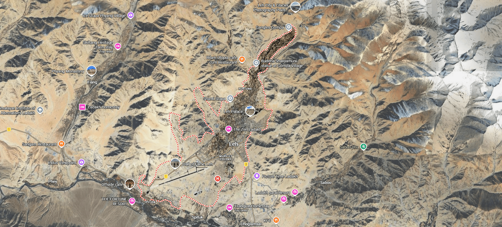
Route map of Leh, base town for the Ladakh Himalayan motorcycle tour — Outriders Co.
👆 Tap For Live Satellite View
Day 02
Delhi → Leh (Flight Into The Sky)
↑ 216m–3500m
A spectacular flight over the Himalayas drops you into Leh at 3,500 m. Hotel check-in, gear check, and altitude acclimatization. Evening briefing, bike allocation, and a short walk to the market for momos and chai. Early night recommended.
Day 3 route map: Leh Acclimatization & Local Ride — Ladakh Himalayan motorcycle tour, Outriders Co.
👆 Tap For Live Satellite View
Day 03
Leh Acclimatization & Local Ride
↑ 3500m–3200m–3500m  🏍 50 Miles
Gentle ride around Leh — Shanti Stupa, Leh Palace, Indus–Zanskar Confluence — just enough to wake up the bikes and the riders. Final gear check, final instructions, no heroics.
Day 4 route map: Leh to Sumur — Ladakh Himalayan motorcycle tour, Outriders Co.
👆 Tap For Live Satellite View
Day 04
Leh → Nubra Valley Via Khardung La
↑ 3500m–5359m–3100m  🏍 75 Miles
The legendary climb to Khardung La, one of the world's highest motorable passes. Views big enough to make your problems feel small. Photo stop, then descend into Nubra's wide valley, monasteries and dunes. Desert, mountains and double-humped camels in one frame.
Day 5 route map: Sumur to Turtuk to Sumur — Ladakh Himalayan motorcycle tour, Outriders Co.
👆 Tap For Live Satellite View
Day 05
Nubra → Turtuk → Nubra
↑ 3100m–2950m–3100m  🏍 150 Miles
Ride to Turtuk, a village with Balti culture and a unique history. Narrow valleys, apricot orchards and stories of a frontier most people never see. Explore Diskit monastery and Hunder dunes, with its double-humped camels, en route.
Day 6 route map: Sumur to Pangong Tso — Ladakh Himalayan motorcycle tour, Outriders Co.
👆 Tap For Live Satellite View
Day 06
Nubra → Pangong Lake (Via Shyok)
↑ 3100m–4350m  🏍 100 Miles
Remote, dramatic route following the Shyok river. Gravel, water crossings and scenery that looks fake. End the day at the legendary Pangong Tso, shining shades of blue during the day, like someone turned up the saturation slider to illegal levels, and freezing by night.
Day 7 route map: Pangong Tso to Leh — Ladakh Himalayan motorcycle tour, Outriders Co.
👆 Tap For Live Satellite View
Day 07
Pangong Tso → Leh Via Chang La
↑ 4350m–5391m–3500m  🏍 100 Miles
The mountains stop being polite. You leave Pangong's postcard blues behind and climb straight into thin air and bad decisions — Chang La, one of the highest motorable passes on the planet. You roll back into Leh dusty, grinning, slightly hypoxic, and absolutely convinced you've earned your dinner.
Day 8 route map: Leh to Kargil — Ladakh Himalayan motorcycle tour, Outriders Co.
👆 Tap For Live Satellite View
Day 08
Leh → Kargil (Lamayuru – Fotu La – Namika La)
↑ 3500m–4108m–2700m  🏍 135 Miles
This ride throws history, geology, and altitude at you in one long, glorious punch. You carve past the moon-scapes of Lamayuru, cross Fotu La and Namika La, and drop into Drass. The Kargil War Memorial stops the jokes cold for a moment, grounding the ride in sacrifice and silence.
Day 9 route map: Kargil to Batalik to Leh — Ladakh Himalayan motorcycle tour, Outriders Co.
👆 Tap For Live Satellite View
Day 09
Kargil → Batalik → Leh Via Hamboting La
↑ 2700m–4100m–3500m  🏍 190 Miles
This is the long way home — and the better one. You peel off toward Batalik, ride tight valleys, punch over Hamboting La high pass, then cruise back via Magnetic Hill where physics messes with your head. By the time Leh shows up, you've earned it.
Route map of New Delhi, arrival and departure hub for Outriders Co. India motorcycle tours.
👆 Tap For Live Satellite View
Day 10
Leh → Delhi (From The Third Pole To City Lights)
↑ 3500m–216m
You say goodbye to the Roof of the World, trading prayer flags and thin air for a spectacular flight back to Delhi. By nightfall, the mountains are behind you and the music is loud — time for a no-holds-barred farewell party. Boots off, stories on repeat.
Day 11 route map: Departure from Delhi — Ladakh Himalayan motorcycle tour, Outriders Co.
👆 Tap For Live Satellite View
Day 11
Departure From Delhi
↑ 216m
Breakfast, airport drop, emotional goodbyes, heartfelt promises to ride again... and a strong chance you'll book the next expedition within a week.
Route Intelligence
Every Stop Logged, Every Distance Measured, Every Altitude Checked, Every Signboard Treated As A Rumour
Red — fuel, permit, hazardGold — why you stopGrey — waypoint
Day 01Arrival in Delhi+
Altitude profileDelhi 700 ft
Arrival day — no riding
Airport pickup — Indira Gandhi International (DEL)
Transfer included

We meet you at Terminal 3 and take you to the group hotel. Delhi sits at roughly 700 ft — the lowest point of the entire expedition, and deliberately so.

Welcome Dinner
Included

First meeting of the full squad, the ride leaders and the mechanic. Route brief, bike allocation preview, and the medical and altitude briefing.

Day 02Delhi → Leh+
Altitude profile700 ft → 11,483 ft
By air · the largest altitude gain of the trip

Altitudes: Delhi 700 ft → Leh 11,483 ft. This is the single largest altitude gain of the trip and the reason Day 03 exists.

Flight Delhi → Leh
Window seat left

The approach into Leh runs along the main Himalayan range — Nun Kun and the Zanskar wall on a clear day. Sit on the left side heading north.

Two-day acclimatization
No exertionNo alcohol

We build two full days of acclimatization into the schedule before anyone rides higher. Altitude does not care how fit you are and there is no way to hurry it. Today is complete rest — no walking tours, no bike riding, 3–4 litres of water.

Bike allocation and gear check

Machines assigned, luggage system explained, and a walk-through of what rides on the support vehicle versus what rides with you.

Day 03Leh Acclimatization & Local Ride+
Distance77 kmAltitude profile11,483 ft → 10,502 ft → 11,483 ft
Day high point 11,969 ft at Namgyal Tsemo

Net sleeping-altitude gain for the day: zero — you sleep at 11,483 ft, the same as the night before. That is the entire point of this day.

KM 0Leh

The loop starts and finishes here.

KM 4Shanti Stupa

A Peace Pagoda on the Chanspa ridge, begun in 1983 and completed in 1991. It was initiated by the Japanese monk Gyomyo Nakamura of the Nipponzan-Myohoji order and built with Ladakhi volunteers and government support, so it is a Japanese-founded pagoda rather than a Japanese-built one. The Dalai Lama laid its foundation relics in 1985. You ride the road to the gate — the 555 steps from the base are an unnecessary exertion load on day three.

KM 6Leh Palace

Nine storeys of mud-brick and timber, raised in the early 17th century by King Sengge Namgyal, who ruled from 1616 to 1642. The present Potala in Lhasa went up in 1645, in the same architectural tradition. Parts of the interior are dark and the building is still under ASI restoration, so carry a torch and watch your footing.

KM 8Namgyal Tsemo gompa

The highest point in Leh town, on the crag above the palace, holding a three-storey gold Maitreya. The last stretch is a steep foot climb on rough steps, at the day's altitude maximum. Optional for anyone feeling the altitude.

KM ~14Hall of Fame
KM approximate

The Indian Army's museum and memorial for this sector — Kargil, Siachen, the Wall of Heroes in black granite, and an outdoor park of tanks and artillery. Established 1986, renovated 2015.

KM 20Spituk gompa

Gelugpa gompa on a hillock beside Leh airport, looking out over the Indus valley, founded in the 11th century and taken over by the Yellow Hats in the 15th. Its giant Vajrabhairava is unveiled only at the Gustor festival. Take it on the way out, not on the way back.

KM 38Gurudwara Pathar Sahib
LangarToilets

Built by the Indian Army around a boulder said to carry the impression of Guru Nanak's body from his 1517 passage through Ladakh. The boulder resurfaced during construction of the Leh–Nimmu road in the 1970s and could not be moved. Free langar for every visitor regardless of faith — and the only verified toilets on the loop.

KM 42Magnetic Hill

A gravity hill, not a magnetic one. The horizon is obscured by the surrounding slopes so the brain misreads a shallow descent as a climb — the road is going downhill the entire time, and our own elevation profile confirms it. It is a live highway, so this is a stop to look at, not to experiment on.

KM 45Sangam — Indus and Zanskar confluence
Cafés

Where the Zanskar comes out of its gorge and meets the Indus, two rivers of visibly different colour running side by side before they mix. Which is which, and how strong the contrast is, changes with the season and the silt the Zanskar is carrying. In deep winter the Zanskar freezes and becomes the Chadar trek — though the walk itself starts upstream at Chilling, not here.

KM 77Return to Leh

Back on NH1 over the rise at Pathar Sahib and down into town. Final gear check, final instructions.

Day 04Leh → Sumur+
Distance146 kmAltitude profile11,483 ft → 17,582 ft → 10,203 ft
Khardung La 17,582 ft · ends at Sumur

Distances measured from Leh. Single-lane two-way traffic holds speeds down even on good tarmac.

KM 0Leh

The day starts in town and climbs straight onto the pass road.

KM 24South Pullu
Tea stalls

The army barrier on the Leh side, and where the climb proper begins.

KM 24→39South Pullu to the summit
15 km

Fifteen kilometres of single-lane switchbacks with two-way traffic. The Border Roads Organisation has resurfaced much of this road in recent years, but the highest stretch still degrades and is patched through the season — expect potholes and rough patches. Ride it as a mountain road, not a highway.

KM 39Khardung La — 17,582 ft
Rinchen Cafeteria

The summit signboard reads 18,380 ft. Independent GPS, SRTM, ASTER and Russian topographic surveys all put it at 17,582 ft,; the figure is endorsed by the Institut Cartogràfic de Catalunya. We publish the surveyed figure and tell you the sign is wrong — you will photograph it and you deserve to know. Keep the stop short — no running about, no smoking, no heavy meal. An army-run cafeteria sits at the top, named after Colonel Chewang Rinchen — usually serving tea, coffee and hot food.

KM 55North Pullu

The barrier on the Nubra side. The drop from the summit to here is the steeper of the two flanks.

KM 71Khardung Village
DhabasTea

First real habitation north of the pass and the village the pass is named for. Greenery and irrigated fields return after the high desert crossing, the road improves markedly, and this is the first point at which it is medically sensible to relax.

KM 94Khalsar — junction and fuel
Fuel (intermittent)Lunch

T-junction on the Shyok where the road splits: west to Diskit, Hunder and Turtuk, north to Sumur and Panamik. There is an IndianOil pump here but it queues badly and runs dry — treat Leh as your last certain fuel, not this.

KM 115Diskit — monastery and the Maitreya
Fuel (reliable)Toilets

Administrative seat of Nubra, with the valley's oldest and largest gompa, founded by Changzem Tserab Zangpo and variously dated to the 14th or 15th century, on the hill above the village. Below it stands the 105 ft Maitreya Buddha, consecrated by the Dalai Lama in July 2010, facing down the Shyok valley toward Pakistan. The most reliable pump in the valley, working even in winter.

KM 146Sumur
Overnight

You turn back east at Khalsar and run up the northern arm of the valley to Sumur. Sumur and the villages around it are your base for the next two nights.

Day 05Sumur → Turtuk → Sumur+
Distance246 kmAltitude profile10,203 ft → 9,390 ft → 10,203 ft
Out-and-back · Turtuk 9,390 ft is the lowest point of the expedition

This is an out-and-back day — you return to Sumur. Distances run westbound from Sumur to the turnaround at Turtuk, then continue as a running total on the way home. Ride the outbound leg early: the gorge becomes a headwind funnel as the day goes on, and stone-fall is flagged on the final approach to Turtuk.

KM 0Sumur — departure
No fuel beyond Diskit

The pump at Diskit is the last fuel west of Khalsar. Everything beyond it — Skuru, Bogdang, Chalunka, Turtuk — has none, and this is a 246 km round trip.

KM 31Diskit
Fuel (reliable)

You pass the pump on the way out and again on the way back. Fill on the return leg, before the last run up to Sumur.

KM 41Hunder — the dunes
Camel rides

A belt of white cold-desert dunes between Diskit and Hunder, grazed by double-humped Bactrian camels — Silk Road caravan stock, left behind when the Karakoram trade route to Yarkand closed in 1950. Take them on the way out or on the way back; the light is best when the sun is low, so the return leg usually wins.

KM 55Thoise airbase — do not stop
Zero stoppingNo photography

A major Indian Air Force forward airfield supporting the Siachen sector, and the road runs directly past it. Photography of the base, aircraft or installations is prohibited. Ride through.

KM 63Skuru

Small Balti hamlet on the Shyok, population 230 at the 2011 census. It marks where the road leaves the broad Nubra plain and enters the narrowing gorge — the character of the ride changes here.

KM 101Bogdang
HospitalDhabas

The first of the Balti villages on this road — 1,988 people at the 2011 census, Balti-speaking, following the Sufi Noorbakshia order, and known for its apricots. There is a Primary Health Centre here and another at Turtuk; neither is equipped for more than first response.

KM 113Chalunka — the Shyok suspension bridge

One of the four villages taken from Pakistan in the 1971 war. A suspension bridge spans the Shyok just before the final approach — the photograph of the day for most riders.

KM 123Turtuk — the turnaround
LunchNo fuelNo signal

Under Pakistani administration until December 1971, taken during the Battle of Turtuk by the Ladakh Scouts and Nubra Guards, with the assault led by Major Chewang Rinchen — the same officer the Khardung La cafeteria is named for, a Colonel by the time he retired. It opened to tourists only in 2010. At 9,390 ft it is the lowest point of the entire expedition, and this cluster of villages is the only part of India populated by Balti people. Turtuk is laid out in two hamlets, Farol and Youl, divided by a glacial stream, and is explored on foot. Park and walk; Balti kitchens in the homestays and cafés make this the meal of the day.

→ Yabgo Palace and Museum, Youl

The Yabgo family traces its line back around a thousand years, and Yabgo Mohammad Khan Kacho receives visitors himself. Swords, old coins, Balti jewellery and sepia photographs of the Baltistan rulers. It is a lived-in family house rather than a curated museum, and you are a guest in it.

→ The natural cold store

Nangchung — ‘cold house’ in Balti. Stone chambers built with deliberate gaps so cold air moves through them, holding meat, butter and dairy through the summer without power. Short walk from the Balti heritage house.

→ Polo ground and the wooden bridge

A 16th-century polo ground still in use — matches are played at Navroz in March — and the wooden suspension bridge between Youl and Farol that is the village's signature photograph. The gompa on the plateau above gives the best all-round view.

KM 205Hunder — westbound light

Back through the dunes with the sun on the other side of the valley. If you skipped the camels on the way out, this is where you take them.

KM 215Diskit — fuel before Sumur
Fuel (reliable)

Fill here. It is the last pump before Sumur and the only one you will pass before the Shyok road.

KM 246Return to Sumur
Overnight

Up the northern arm of the valley to Sumur. Same road as you rode out on, completely different photographs. You have not moved base.

Day 06Sumur → Pangong Tso+
Distance178 kmAltitude profile10,203 ft → 14,272 ft → 14,049 ft
14,272 ft is the road high point · Pangong Tso itself is 13,862–13,914 ft

Distances measured from Sumur. The hard part is a single 24 km unsurfaced section east of Agham — not the whole day.

KM 0Sumur — departure
Early start is the safety marginLast fuel for 126 km

You fuelled at Diskit yesterday, and the next pump is Tangtse, 126 km on, with the whole unpaved section in between. We start early because the unpaved section is slow and the day is long.

KM 22Khalsar — the turn
Dhabas

Where the Shyok valley road splits from the Khardung La highway. Straight climbs back over the pass to Leh; the right turn follows the river east.

KM 52Agham

The last village before the unpaved section along the Shyok.

KM 52–76The unpaved section
24 km

Twenty-four kilometres of unsurfaced road along the Shyok between Agham and Shyok village, where the built road resumes. This is the slow part of the day.

KM 97Shyok Village
DhabasLunch

A green oasis in the gorge, historically on the winter caravan route from Leh to Yarkand and on to Kashgar over the Karakoram Pass until 1937. Dhabas now run here — Maggi, soup and chai — and the tarmac resumes.

KM 115Durbuk

T-junction onto the main Leh–Chang La–Pangong highway, and the southern trailhead of the Darbuk–Shyok–Daulat Beg Oldi strategic road, completed in April 2019, which runs north from here to the Daulat Beg Oldi post. From here it is good tarmac all the way.

KM 126Tangtse — last fuel, hot food
Fuel

The Tangtse Pangong Filling Station is listed by IndianOil as open 24 hours — older guides that name Karu as the last pump are out of date. We cannot confirm winter operation, so treat winter fuel here as unavailable. Tangtse is also the most important rock-art site in Ladakh, with around 300 petroglyphs and 70 inscriptions in Tocharian, Sogdian, Sharada and Arabic script from its days on the Turkestan–Tibet trade route.

KM 158First sight of Pangong Tso

The first sight of the lake, from the road above its western end.

KM 164Lukung
Tea stalls

The village sits back from the water near the lake's western end — a waypoint, not a destination.

KM 178Spangmik — Pangong Tso
OvernightCamps set back from shore

The lake runs 134 km, of which roughly a third to 40% lies on the Indian side. The alignment here is disputed: India places the Line of Actual Control at Finger 8, China puts it at Finger 2. The western basin is saline at 11 g/l and the eastern fresh, and the whole thing freezes solid in winter despite the salt. A 2018 High Court order required the removal of commercial structures on the lakeshore, and the district administration demolished them in April 2019. Licensed camps now sit back from the waterline inside the village boundary. Expect limited and intermittent power.

Day 07Pangong Tso → Leh+
Distance162 kmAltitude profile14,049 ft → 17,586 ft → 11,483 ft
Chang La 17,586 ft · the highest point of the expedition

Distances measured from Spangmik. The climb from Durbuk to the pass is about 30 km gaining roughly 5,050 ft, an average of about 5% — the hardest sustained work of the day for both rider and machine.

KM 0Spangmik
No fuel

Breakfast and lakeside light before you leave. The first nine kilometres out are typically the roughest of the day.

KM 9Surtok junction

The lake's western end, where the road to Phobrang and Marsimik La branches north. Lukung village proper is a few kilometres up that branch.

KM 42Tangtse — fuel and lunch
FuelDhabas

Refuel here. The road ahead climbs about 5,050 ft.

KM 50Durbuk
DhabasToilets

Last easy break before the climb. Headquarters of Durbuk subdivision, sitting between the Indus valley west, the Shyok east and Pangong south.

KM 81Chang La — 17,586 ft
Army teaEmergency oxygen

The highest point of your entire expedition, and the gateway from the Indus valley onto the Changthang plateau. Two independent satellite elevation models put the road summit at 17,575–17,608 ft, bracketing the signboard figure — the sign is right here, unlike at Khardung La. There is an army-run tea point at the pass, and the DRDO has run a high-altitude research station here since 2015 — the highest in the world. Keep the stop short.

→ Chang La Baba shrine
Included in the stop

A shrine to Chang La Baba stands at the summit. The story that the pass is named after a sadhu of that name is folk etymology, and is contradicted on the J&K tourism corporation’s own page. The name is Tibetan: la is pass, and chang is the same element as in Changthang, the plateau the pass opens onto.

KM 93Zingral

Remote army settlement on the descent, below the steep first section off the top. Expect the same loose surface and running water for the first few kilometres below the pass.

KM 113Sakti
HomestaysNo ATM

Junction village at the foot of the climb, and the base for Takthok — the only Nyingma monastery in Ladakh, built around a meditation cave attributed to Guru Padmasambhava. The long descent into here is where brake temperature and rider fatigue matter more than the surface.

KM 115Chemrey gompa

Founded in 1664 by Lama Tagsang Raschen and dedicated to King Sengge Namgyal, holding a storey-high Padmasambhava and a 29-volume scripture set written in gold and silver letters. Sits a short way off the road on its own ridge.

KM 123Karu — fuel and NH3
FuelDhabas

Where the Chang La road meets the Manali–Leh highway. There is an IndianOil pump here, on the Manali road.

KM 141Thiksey gompa

Twelve storeys stacked up a hill, the largest gompa in central Ladakh and universally called the mini Potala. Its 49 ft Maitreya spans two floors and was installed in 1970 to mark the Dalai Lama's visit — the largest such statue in Ladakh. Two cafés and toilets at the base.

KM 147Shey Palace

Summer capital of the Namgyal kings, with a 39 ft Shakyamuni gilded in gold, built in 1655 by King Deldan Namgyal — the second largest Buddha statue in Ladakh, after Thiksey’s Maitreya. Ruined palace walls, a chorten field and the Indus valley laid out below. Ask before photographing inside.

KM 162Leh

Back into town on NH3 through Choglamsar. Full services, workshops, ATMs.

Day 08Leh → Kargil+
Distance220 kmAltitude profile11,483 ft → 13,478 ft → 8,780 ft
Fotu La 13,478 ft · the highest point on the whole Srinagar–Leh highway

Distances measured from Leh, all on NH1. Sealed tarmac for effectively the whole route, subject to BRO roadworks — technically the easiest surface of any Ladakh riding day.

KM 0Leh

The whole day runs on NH1, the Srinagar–Leh highway.

KM 25Gurudwara Pathar Sahib
LangarToilets

The Sikh shrine built by the Indian Army around Guru Nanak's boulder. Free meal for anyone who wants one, and the best toilets for the next hundred kilometres.

KM 29Magnetic Hill

The gravity hill. Our elevation profile shows the road dropping through here — it is going down the whole way.

KM 32Sangam — Indus and Zanskar confluence

The two rivers meeting in visibly different colours. In winter this is the turn-off for the Chadar trek — the walk on the frozen river itself starts at Chilling, some 30 km further up the Zanskar.

KM 36Nimmu
CafésToilets

The practical breakfast halt out of Leh.

KM 43Basgo

A hilltop monastery standing over the ruins of the old town — a political and cultural centre of early Ladakh, named repeatedly in the Ladakhi Chronicles. A palace stood here in the 15th century; the monastery complex was built for the Namgyal rulers in 1680 and holds three Maitreya temples — Chamchung, Chamba Lakhang and Serzang.

KM 68Alchi gompa — the detour worth taking
+9 km round tripNo photography inside

Not on the highway — you cross the Indus at Saspol bridge to the south bank. Alchi holds some of the oldest surviving murals in Ladakh, painted by Kashmiri artists in the 12th to early 13th century — the traditional attribution to Rinchen Zangpo in the 11th is not supported by the inscriptions — in a style so ornate it has been called baroque, preserving Kashmiri Buddhist iconography that no longer survives in Kashmir itself. Unusually for Ladakh it sits on the valley floor, not a crag. Photography inside is strictly prohibited to protect the pigments, and it is enforced.

KM 85Nurla
Cafés

Riverside tea halt on the long descent along the Indus.

KM 94Khaltse — fuel stop and lunch
Fuel reported, not confirmedLunch

The low point of the day, about 400 m below Leh. A pump is reported here but it does not appear in the official IndianOil database, so treat it as probable rather than guaranteed — the same caution applies coming the other way on Day 09. From here it is 126 km and two passes — Fotu La at 13,478 ft and Namika La at 12,139 ft — to the next confirmed IndianOil pump, which is at Kargil. Ladakh pumps can run dry in season, so the support vehicle carries reserve.

KM 114Lamayuru — the moonland, 11,516 ft
Puncture repair

The moonland is not folklore. Lamayuru sits in a palaeolake basin: a tectonically triggered landslide dammed the river in the Late Pleistocene, and the lake laid down over 330 ft of pale silts and clays with annual varves from around 35,000 years ago until roughly a thousand years back. When it drained, those soft pale sediments eroded into badlands — that is the lunar look. The monastery's oldest building dates to the 10th–11th century and is attributed to Rinchen Zangpo; by Drikung tradition it was founded by Naropa, who dried the lake up.

KM 130Fotu La — 13,478 ft
No facilities

The highest point on the entire Srinagar–Leh highway, and we checked rather than repeating the claim: we profiled the other half of the highway and Zoji La tops out at about 11,575 ft. Fotu La beats it by roughly 1,900 ft. A broad wind-scoured saddle with chortens, reached by the long switchback climb out of Lamayuru — the signature riding of the day.

KM 152Bodh Kharbu
Tea

Village on the valley floor between the two passes, with an army presence. Do not photograph installations or convoys.

KM 166Namika La — 12,139 ft

The Pillar of the Sky, from the Tibetan gnam gyi ka la. The second and lower of the two passes — a rounded ochre saddle with chortens, and the classic photograph for the two-pass set.

KM 181Mulbekh — the Maitreya rock carving
FuelRoadside

A colossal four-armed Maitreya cut into an isolated rock outcrop right beside the highway, roughly 25 to 30 feet high. Dates from the 7th to the 12th century have been proposed, with recent scholarship favouring the late 10th or early 11th — there is no contemporary inscription, so the dating rests on style alone. The stupa in its headdress is what identifies it as Maitreya. Kashmiri in style, which makes it and Alchi a genuinely coherent pair on one day's ride.

KM 220Kargil
OvernightFuelMechanicsLoC 11 km north

Ladakh's second town, on the Suru river, predominantly Muslim in character after a day of Buddhist villages. The Line of Control sits roughly eleven kilometres north — in 1999 Pakistani forces shelled this highway from the ridges above. No photography of military installations, checkposts, convoys or personnel, and no drones. Best workshop capability between Leh and Srinagar.

Day 09Kargil → Batalik → Leh+
Distance231 kmAltitude profile8,780 ft → 13,287 ft → 11,483 ft
Hamboting La 13,287 ft

Distances measured from Kargil. The pass comes first, not mid-route — you climb about 4,500 ft out of Kargil in the opening 34 km, cross, then drop to the Indus and run the valley east.

KM 0Kargil — fill completely
Last certain fuel for 195 km

Two pumps in town. The next confirmed pump is at Nimmu, 195 km away — Khaltse has one reported but it is not in the official database.

KM 34Hamboting La — 13,287 ft
No facilities

The day's only high point and its opening act — about 4,500 ft of continuous climb from Kargil in thirty-four kilometres, on a narrow, well-surfaced road with sheer drops along virtually its entire length and hairpin after hairpin. Usually impassable in winter.

KM 48Silmo
Pass through

Small village on the descent toward the Indus.

KM 53Batalik
No fuelNo accommodation

A narrow section of the Indus valley close to the Line of Control, and one of the four main theatres of the 1999 Kargil War — Indian forces retook Jubar, Point 5203 and Khalubar Ridge here, and Captain Manoj Kumar Pandey was awarded a posthumous Param Vir Chakra for action in this sector. No photography of any military position.

KM 60Darchik
Pass through or brief stop

First of the Brokpa villages on the route.

KM 65Garkone

Brokpa village, one of the four core clusters with Dah, Hanu and Darchik. Homestays operate here.

KM 70Dah — the Brokpa heartland
Ask before photographing

The Brokpa — Minaro in their own oral history — are a Dardic group of roughly three thousand people in Ladakh, speaking Brokskat, an endangered language with no standard written form, and predominantly Vajrayana Buddhist. The elaborate floral headgear you have seen in photographs is ceremonial — expect to see it at the Bono-na festival rather than on an ordinary morning. We do not call this the Aryan Valley. That label dates from around 2010 tourism marketing, has no scientific basis — genetic work points elsewhere entirely — and carries a documented history of racial tourism this company wants no part of. Ask before every photograph, accept refusal, and never photograph inside homes or children.

KM 75Biama — lunch
HotelMonastery

The first real Brokpa village on the main road, and the lunch stop on the Indus stretch.

KM 85Hanu Thang

The roadside settlement. The Hanu villages proper sit up a side valley to the north, too far off the line to fit this day.

KM 94Achinathang

The greenest of the Brokpa villages, with ancient petroglyphs documented in the Ladakh rock-art record.

KM 108Skurbuchan

Larger village with a gonpa on the hill above, in apricot country. The stretch in from Achinathang is the most tortuous road geometry of the day.

KM 116Domkhar Rock Art Sanctuary
Protected site

One of the finest collections of rock art in Ladakh, unmatched in the region for beauty and diversity. Notified as a protected monument by the Ladakh administration in July 2026, and almost entirely unvisited. Genuinely worth the stop — arguably better value than a token village drive-through.

KM 134Khaltse — rejoin NH1
Fuel (probable)Dhabas

End of the remote section. A pump is reported here by multiple sources but does not appear in the official IndianOil database — treat it as probable, not guaranteed. Reliable dhabas.

KM 195Nimmu / Sangam
Fuel confirmedCafés

Confirmed pump, and the Indus–Zanskar confluence just before the village.

KM 202Magnetic Hill

The gravity hill on the run in to Leh.

KM 231Leh

Home. A long day, and the quietest riding of the whole expedition.

Day 10Leh → Delhi+
Altitude profile11,483 ft → 700 ft
By air
Flight Leh → Delhi

Leh airport clears early and weather cancellations happen — the transfer leaves the hotel well before dawn.

Farewell party, Delhi
Included

Certificates, the ride video, and the stories that have grown considerably since Khardung La.

Day 11Departure from Delhi+
Altitude profileDelhi 700 ft
Departure day
Airport drop
Transfer included

We run the transfer to suit your flight. Bear in mind Delhi traffic and international check-in requirements.

Inclusions & Exclusions

MISSION PAYLOAD

OPERATOR EXCLUSIONS

Inclusions & Exclusions
Mission Payload
Royal Enfield Himalayan or Similar Motorcycle
Fuel and Oil for The Entire Route
All Accommodation (Double Occupancy) & All Meals
Support Vehicle (Luggage & Spares)
Mechanic & Ride Leaders
Oxygen Cylinder
Personalized T-shirt/Hoodie
Welcome Dinner & Farewell Party
Operator Exclusions
International/Domestic Flights
Travel Visa
Personal Travel Insurance
Alcohol & Beverages
Personal Riding Gear
Damages to Motorcycle
Room Service, Laundry, Tips
Anything Not Specifically Mentioned Under 'Inclusions'

ARE YOU A GOOD FIT?

YOU'RE AN OUTRIDER IF

SAVE YOUR MONEY IF

Are You A Good Fit?
You're An Outrider If
You want big-altitude riding
You can respect acclimatization
You're comfortable with riding on mixed surfaces
You like remote landscapes where silence is the reward
You can stay calm when plans flex
You prefer calm competence over loud bravado
Save Your Money If
Cold nights and dust do not sound like adventures
The phrase "limited services" triggers existential dread
You treat group rides like solo missions with witnesses
You confuse bravery with stupidity and ride accordingly
You need Wi-Fi like normal people need air
The word "remote" makes you anxious instead of excited
Start Rider Assessment →